Butler Range (Canterbury) facts for kids
Quick facts for kids Butler Range |
|
|---|---|

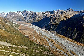
Butler Range (top centre) to the right of the Rakaia River
|
|
| Geography | |
| Country | New Zealand |
| Region | Canterbury |
| Range coordinates | 43°13′S 170°55′E / 43.217°S 170.917°E |
The Butler Range is a cool mountain range found in the Ashburton District of Canterbury, which is on the South Island of New Zealand. Imagine a long line of mountains! This range sits right next to the Rakaia River to its south.
Discovering the Butler Range
Location and Landscape
The Butler Range is part of the amazing Southern Alps, which are the main mountains running down the spine of New Zealand's South Island. It's located in a beautiful area known for its stunning natural views and wide-open spaces. The mighty Rakaia River flows nearby, adding to the scenic beauty of the region. This river is one of the largest braided rivers in New Zealand, meaning it splits into many small channels.
Naming the Mountains
The Butler Range gets its name from an interesting person named Samuel Butler. He was a famous English writer and farmer. Back in the 1860s, Samuel Butler was one of the first people to farm in this area. He called his large farm "Mesopotamia Station". It's pretty neat that a whole mountain range is named after him!
The Tallest Peaks
The highest point in the Butler Range is called Lauper Peak. This peak stands incredibly tall at 2,485 metres (8,153 ft) (that's about 8,153 feet!). Lauper Peak was named after a Swiss explorer named Jakob Lauper. He was one of the first people to explore and map parts of the Southern Alps.
Another important peak in the range is Mount Butler. This mountain is also named after Samuel Butler, just like the range itself. Mount Butler is a bit shorter than Lauper Peak, reaching 2,103 metres or 6,900 feet (about 6,899 feet) into the sky. Both peaks offer amazing views of the surrounding landscape.

