Butler Range (West Coast) facts for kids
Quick facts for kids Butler Range |
|
|---|---|

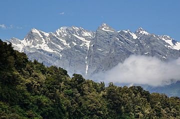
Butler Range some distance upstream from State Highway 6
|
|
| Geography | |
| Country | New Zealand |
| Region | West Coast |
| Range coordinates | 43°23′S 170°29′E / 43.383°S 170.483°E |
The Butler Range is a mountain range in New Zealand. It is found on the South Island in the West Coast Region. Sometimes, people call it the North Butler Range or even the Peaks of the Mist Range.
Contents
Exploring the Butler Range
Where is the Butler Range?
The Butler Range is in the Westland District, which is part of the West Coast Region of New Zealand's South Island. You can often see the range from State Highway 6 as it crosses the Whataroa River.
How Did It Get Its Name?
The Butler Range was likely named by a person called Charlie Douglas. He probably named it in the late 1890s. The range was named after John Butler, who lived in a place called Whataroa.
Tall Peaks and Glaciers
Because the Butler Range is quite isolated, some of its mountain tops were not climbed until the 1940s. Here are some of the named peaks in the range, listed from west to east:
- Bamford Knob: This peak is about 1,845 meters (6,053 feet) tall.
- Tohunga Peak: It stands at about 1,926 meters (6,319 feet) high.
- Mount Whataroa: This mountain is about 2,123 meters (6,965 feet) tall. It was first climbed in 1949.
- Mount Rangatira: This peak reaches about 2,157 meters (7,077 feet) high.
- Mount Ariki: The tallest of these named peaks, it is about 2,193 meters (7,195 feet) high. It was also first climbed in 1949.
Rivers and Lakes Around the Range
South of the Butler Range, you can find the Whataroa Glacier and a place called Ice Lake. The Butler River also flows here. This river eventually joins the Whataroa River, which then flows into the Tasman Sea. On the northern side, the Butler Range is bordered by the Perth River.
North and South Butler Ranges
Some mountain climbers use the name "South Butler Range" for another range of mountains. This other range is located south of the Butler River. It stretches from King Peak to Mount Huss, which is on the Main Divide. Mount Barrowman and Dog Kennel Peak are two peaks in this "South Butler Range." To avoid confusion, the main Butler Range is sometimes called the North Butler Range.

