
Butterworth Hall Brook facts for kids
Quick facts for kids Butterworth Hall Brook |
|
|---|---|

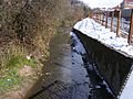
Water Lane in 2008
|
|
| Country | England |
| Physical characteristics | |
| Main source | Tunshill |
| River mouth | River Beal, Milnrow Precinct 53°36′26.21″N 2°06′29.19″W / 53.6072806°N 2.1081083°W |
The Butterworth Hall Brook is a small stream in Greater Manchester, North-West England. It flows through the village of Milnrow and eventually joins the River Beal. Even though it's quite short, it plays a part in the local landscape and history.
The Brook's Journey
The Butterworth Hall Brook starts its journey high up at Tunshill, just south of Tunshill Farm. Right away, it gets more water from a tiny stream.
From there, the brook flows southwest towards Milnrow. It goes into a tunnel (called a culvert) under the busy M62 Motorway. After that, it runs along the eastern edge of Tunshill Golf Course.
It then flows down a small valley, known as a "clough," through an area called Claylands Head. This leads it to the tiny village of Butterworth Hall.
The brook continues past a place called Good Intent. It then goes into another tunnel under Church Terrace. Finally, it flows under Bilson Bridge on Newhey Road.
Right behind the Milnrow Precinct shopping area, the Butterworth Hall Brook joins the River Beal. From where it starts to where it ends, the brook drops about 55 meters (180 feet). It's a short stream, barely longer than 2 kilometers (about 1.25 miles).
Why the Name?
The Butterworth Hall Brook gets its name from the small village of Butterworth Hall. This village grew up around an old manor house. This manor house was once the main building of the ancient area known as Butterworth.
Gallery
-
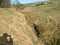
Upstream from the M62
-
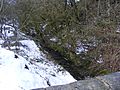
Downstream from Claylands Head
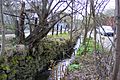
-
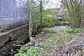
Water Lane upstream
-
Milnrow Precinct
-
Confluence with River Beal


