Caimito, Cuba facts for kids
Quick facts for kids
Caimito
|
|||||
|---|---|---|---|---|---|

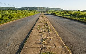
The road to Guayabal outside Caimito
|
|||||
|
|||||

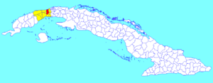
Caimito municipality (red) within
Artemisa Province (yellow) and Cuba |
|||||
| Country | |||||
| Province | Artemisa | ||||
| Founded | 1910 | ||||
| Area | |||||
| • Total | 238 km2 (92 sq mi) | ||||
| Elevation | 95 m (312 ft) | ||||
| Population
(2022)
|
|||||
| • Total | 42,552 | ||||
| • Density | 178.8/km2 (463.1/sq mi) | ||||
| Time zone | UTC-5 (EST) | ||||
| Area code(s) | +53-7 | ||||
| Climate | Am | ||||
Caimito is a town and a municipality in the Artemisa Province of Cuba. The town was started in 1820. The area officially became the municipality of Caimito in 1910.
Geography of Caimito
Caimito is divided into several smaller areas, like villages. These include Caimito, Guayabal, and Ceiba del Agua. Other villages are Pueblo Nuevo, Rancho Grande, and Capellanías. You can also find Vereda Nueva, Los Naranjos, Aguacate, Banes, Habana Libre, and Menelao Mora.
People Living in Caimito
In 2022, about 42,552 people lived in the municipality of Caimito. The total area of Caimito is about 238 square kilometers (92 square miles). This means there are about 180 people living in each square kilometer.
Getting Around Caimito
Caimito is easy to reach by road. The main road in Cuba, the Carretera Central, goes through the town. The A4 motorway also passes a few kilometers north of Caimito.
Since 2014, Caimito has a railway station. This station is part of a new train line connecting Havana to Guanajay, Artemisa, and Mariel. This line is also part of the bigger Havana-Artemisa-Pinar del Río line.
The Playa Baracoa Airport is located within Caimito's area. This airport serves the city of Havana. It is right in front of Playa Baracoa, which is a village in the nearby municipality of Bauta.
See also
 In Spanish: Caimito (Cuba) para niños
 | Kyle Baker |
 | Joseph Yoakum |
 | Laura Wheeler Waring |
 | Henry Ossawa Tanner |


