Cairdbeign, Queensland facts for kids
Quick facts for kids CairdbeignQueensland |
|||||||||||||||
|---|---|---|---|---|---|---|---|---|---|---|---|---|---|---|---|
| Population | 70 (2021 census) | ||||||||||||||
| • Density | 0.185/km2 (0.48/sq mi) | ||||||||||||||
| Postcode(s) | 4722 | ||||||||||||||
| Area | 379.0 km2 (146.3 sq mi) | ||||||||||||||
| Time zone | AEST (UTC+10:00) | ||||||||||||||
| LGA(s) | Central Highlands Region | ||||||||||||||
| State electorate(s) | Gregory | ||||||||||||||
| Federal Division(s) | Flynn | ||||||||||||||
|
|||||||||||||||
Cairdbeign is a small, quiet area in the countryside of Queensland, Australia. It's known as a rural locality and is part of the Central Highlands Region. In 2021, about 70 people lived there.
Exploring the Land
Cairdbeign has some interesting mountains that add to its natural beauty.
- Rainworth Hill is the tallest, standing at 569 meters (about 1,867 feet) above sea level.
- Mount Sirius is another notable peak, reaching 532 meters (about 1,745 feet) high.
- Mount Cassillis is 514 meters (about 1,686 feet) above sea level.
A Look Back in Time
Cairdbeign has a bit of history, especially with its old school. The Cardbeign Provisional School first opened around 1894. Later, on January 1, 1909, it became the Cardbeign State School.
The school sometimes closed and reopened. This happened when the number of students changed a lot. It finally closed for good around 1931. You might notice the school's name is spelled slightly differently from the area's name. The old school was located on Dalmally Road.
Who Lives Here?
The number of people living in Cairdbeign has changed a little over the years.
- In 2016, about 85 people lived in Cairdbeign.
- By 2021, the population was 70 people.
Special Places
Cairdbeign is home to some heritage-listed sites. This means these places are important because of their history or special features. They are protected so future generations can enjoy them.
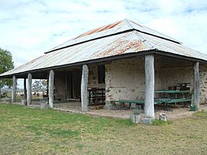
One important site is the Old Rainworth Stone Store. You can find it on Wealwandangie Road. This old store is a great example of the area's past.
 | Shirley Ann Jackson |
 | Garett Morgan |
 | J. Ernest Wilkins Jr. |
 | Elijah McCoy |


