Calabogie Lake facts for kids
Quick facts for kids Calabogie Lake |
|
|---|---|

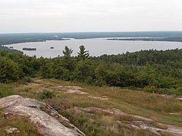
Calabogie Lake seen from Calabogie Peaks
|
|
| Location | Renfrew County, Ontario |
| Coordinates | 45°16′38″N 76°44′34″W / 45.27722°N 76.74278°W |
| Part of | Saint Lawrence River drainage basin |
| Primary inflows | Madawaska River |
| Primary outflows | Madawaska River |
| Basin countries | Canada |
| Max. length | 6.5 km (4.0 mi) |
| Max. width | 4.0 km (2.5 mi) |
| Surface elevation | 155 m (509 ft) |
Calabogie Lake ( KAL-ə-BOH-ghee) is a special type of lake called a reservoir in Ontario, Canada. It's located in Renfrew County, within the area of Greater Madawaska. This lake is part of the Madawaska River system. All the water from this area eventually flows into the huge Saint Lawrence River.
Contents
How Calabogie Lake Was Formed
Calabogie Lake wasn't always this size. It grew much larger when a dam and a power station were built during World War I. This project created the current reservoir. A reservoir is like a big, artificial lake where water is stored, often to help create electricity.
The Calabogie Dam and Power Station
The dam and power station at Calabogie are now managed by Ontario Power Generation. They help control the water flow and generate electricity for homes and businesses.
Communities Around the Lake
Several communities are located right on the shores of Calabogie Lake. These include:
- Calabogie
- Grassy Bay
- Barryvale
You can drive along the lake on Renfrew County Road 511, which crosses the lake in Calabogie. Renfrew County Road 508 also runs along the northwest side of the lake.
Rivers and Streams Flowing In
Many smaller rivers and streams flow into Calabogie Lake, bringing fresh water. These are called tributaries.
- Stoughtons Creek
- Madawaska River (which also flows out of the lake)
- Constant Creek
 | Dorothy Vaughan |
 | Charles Henry Turner |
 | Hildrus Poindexter |
 | Henry Cecil McBay |


