
California Historical Landmarks in Calaveras County facts for kids
Calaveras County in California is a special place, full of history from the exciting days of the California Gold Rush. Many important locations here are recognized as California Historical Landmarks. These landmarks help us remember and learn about the past. They include old towns, historic buildings, and other sites that played a big part in shaping California.
You can explore these landmarks and imagine what life was like long ago. Many of them tell stories of gold miners, pioneers, and the growth of communities in the 1800s.
Contents
Historic Towns and Districts
Many towns in Calaveras County are themselves historical landmarks because they have kept their old charm and stories.
Angels Camp

Angels Camp is a famous historic town. It was a busy mining camp during the Gold Rush. The town is well-known for its annual Jumping Frog Jubilee, inspired by a Mark Twain story.
Angels Hotel
The Angels Hotel in Angels Camp is a very old and important building. It was built in 1855 and has hosted many famous people over the years. It's also listed on the National Register of Historic Places, which means it's recognized nationally for its history.

Altaville
Altaville is another historic district. It's located on State Highway 49. This area was once a busy center for miners and settlers.
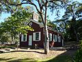
Red Brick Grammar School
In Altaville, you can find the Red Brick Grammar School. This old school building, built in 1858, is a great example of early California architecture. It's also on the National Register of Historic Places.

Copperopolis
Copperopolis is a historic district known for its copper mining history. Unlike many Gold Rush towns, Copperopolis focused on mining copper, which was important for industry.

Mokelumne Hill
Mokelumne Hill was one of the richest gold mining towns in California. It was even the county seat for a while.
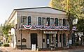
Courthouse and Léger Hotel
The Courthouse of Calaveras County and the Léger Hotel in Mokelumne Hill is a significant landmark. This building served as the county courthouse from 1852 to 1866. It then became the Léger Hotel, a popular stop for travelers.

Murphys
Murphys is a charming historic town nestled among giant sequoia trees. It was a thriving mining town and a supply center during the Gold Rush.

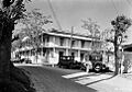
Murphys Hotel
The Murphys Hotel is a famous landmark in Murphys. Built in 1856, it's known for hosting many famous guests, including presidents and writers. It's also called the Mitchler Hotel and is listed on the National Register of Historic Places.

San Andreas
San Andreas became the county seat of Calaveras County in 1866. It was a major center during the Gold Rush, with many miners passing through.

Other Important Landmarks
California Caverns
California Caverns are a natural wonder located in Cave City. These limestone caves have been explored since the Gold Rush era and are a fascinating place to visit.

Chili Gulch
Chili Gulch near Mokelumne Hill was named after a group of Chilean miners who settled there during the Gold Rush. It was a site of early mining activity.
Double Springs
Double Springs was the very first county seat of Calaveras County, from 1850 to 1851. It played an important role in the early organization of the county.
Pioneer Cemetery
The Pioneer Cemetery near San Andreas is a historic burial ground. It holds the graves of many early settlers and miners, telling stories of the people who built these communities.
Robinson's Ferry
Robinson's Ferry was an important crossing point on the Stanislaus River. Ferries like this were vital for transporting people and goods during the Gold Rush, connecting different mining areas.
Images for kids
-
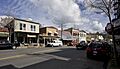
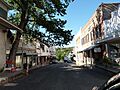
Downtown Angels Camp, a historic district.
-
The historic Angels Hotel in Angels Camp.
-
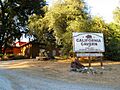
The visitor center at California Caverns.
-
An old building in Copperopolis.
-
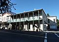
The Léger Hotel in Mokelumne Hill, once the county courthouse.
-
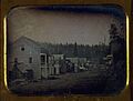
A historical view of Murphys, California.
-
The historic Murphys Hotel.
-
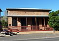
The historic Red Brick Grammar School in Altaville.
-
Main Street in historic San Andreas.
