Callangate facts for kids
Quick facts for kids Callangate |
|
|---|---|
 |
|
| Highest point | |
| Elevation | 6,110 m (20,050 ft) |
| Prominence | 1,403 m (4,603 ft) |
| Parent peak | Ausangate |
| Geography | |
| Location | Cusco Region, Peru |
| Parent range | Andes, Vilcanota |
| Climbing | |
| First ascent | 30 July 1957, Günther Hauser, Bernhard Kuhn (Germany) |
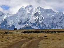
Callangate, sometimes spelled Ccallangate, is a very tall mountain in the Andes mountain range in Peru. It is part of a group of mountains called the Vilcanota range.
The highest point of Callangate is named Collpa Ananta. This name might come from old languages like Aymara and Quechua, meaning "saltpeter." Collpa Ananta is also sometimes called Chimboya.
This amazing mountain stands 6,110 meters (about 20,046 feet) tall. Another peak in this mountain group is also called Ccallangate.
Where is Callangate?
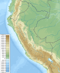
Callangate is located in the Cusco Region of Peru. Specifically, it is in the Quispicanchi Province, within the Ocongate District.
Collpa Ananta is the second-highest mountain in the entire Cusco Region. It also ranks as the 24th highest mountain in all of Peru.
Who First Climbed Callangate?
The first people to reach the top of Callangate were two German climbers. Their names were Günther Hauser and Bernhard Kuhn. They made their historic climb on July 30, 1957.
How Tall is Callangate?
Callangate's highest point, Collpa Ananta, is 6,110 meters (20,046 feet) high. Other measurements, like those from digital maps, show it as 6,104 meters.
The mountain's "prominence" is 1,403 meters. This means it rises that much higher than the lowest point connecting it to a taller mountain. Callangate's "parent peak" (the closest higher mountain) is Ausangate.
See Also
 In Spanish: Callangate para niños
- Condoriquiña
- Comercocha
- List of mountains in Peru
- List of mountains in the Andes
 | Jessica Watkins |
 | Robert Henry Lawrence Jr. |
 | Mae Jemison |
 | Sian Proctor |
 | Guion Bluford |


