
Camargo, Chuquisaca facts for kids
Quick facts for kids
Camargo
|
|
|---|---|
 |
|

Camargo, Chuquisaca
Location in Bolivia
|
|
| Country | |
| Department | Chuquisaca Department |
| Province | Nor Cinti Province |
| Population
(2008)
|
|
| • Total | 5,685 |
| Time zone | UTC-4 (BOT) |
Camargo is a small town located in the Chuquisaca Department of Bolivia. It's found in the amazing Andes mountains of South America.
Contents
Where is Camargo Located?
Camargo is the main town, or capital, of Nor Cinti Province. It sits in the area called Camargo Municipio. The town is nestled between tall mountain ridges that run from north to south.
It's about 2,414 meters (7,920 feet) above sea level. You can find Camargo right on the banks of the Río Chico river. This river later becomes the Río Pilaya.
Camargo is located about 350 kilometers (217 miles) south of Sucre, which is the capital city of the department. The town is along Ruta 1, a very important road in Bolivia. This road is 1,215 kilometers (755 miles) long. It stretches from the border with Peru in the north all the way to the border with Argentina in the south.
How Many People Live in Camargo?
The number of people living in Camargo has grown quite a bit over the last 20 years.
- In 1992, about 3,789 people lived there.
- By 2001, the population increased to 4,502.
- In 2008, it was estimated that 5,685 people called Camargo home. This means the town's population grew by 50% in two decades!
What is the Weather Like in Camargo?
Camargo has a varied climate throughout the year. Here's a quick look at the weather:
| Climate data for Camargo (San Roque), elevation 2,300 m (7,500 ft), (1975–1999) | |||||||||||||
|---|---|---|---|---|---|---|---|---|---|---|---|---|---|
| Month | Jan | Feb | Mar | Apr | May | Jun | Jul | Aug | Sep | Oct | Nov | Dec | Year |
| Mean daily maximum °C (°F) | 28.0 (82.4) |
27.7 (81.9) |
27.7 (81.9) |
27.2 (81.0) |
25.8 (78.4) |
24.2 (75.6) |
23.5 (74.3) |
25.3 (77.5) |
26.5 (79.7) |
29.3 (84.7) |
29.6 (85.3) |
29.0 (84.2) |
27.0 (80.6) |
| Daily mean °C (°F) | 20.4 (68.7) |
20.0 (68.0) |
19.8 (67.6) |
18.0 (64.4) |
14.7 (58.5) |
12.7 (54.9) |
12.6 (54.7) |
14.6 (58.3) |
16.7 (62.1) |
20.0 (68.0) |
21.0 (69.8) |
21.2 (70.2) |
17.6 (63.8) |
| Mean daily minimum °C (°F) | 12.9 (55.2) |
12.4 (54.3) |
12.0 (53.6) |
8.6 (47.5) |
3.6 (38.5) |
1.2 (34.2) |
1.8 (35.2) |
3.9 (39.0) |
7.0 (44.6) |
10.7 (51.3) |
12.5 (54.5) |
13.4 (56.1) |
8.3 (47.0) |
| Average precipitation mm (inches) | 59.1 (2.33) |
67.1 (2.64) |
49.4 (1.94) |
5.9 (0.23) |
0.0 (0.0) |
0.1 (0.00) |
0.0 (0.0) |
2.2 (0.09) |
4.5 (0.18) |
15.3 (0.60) |
32.3 (1.27) |
50.7 (2.00) |
286.6 (11.28) |
| Average precipitation days | 8.2 | 8.0 | 6.4 | 0.9 | 0.0 | 0.0 | 0.0 | 0.4 | 0.6 | 2.0 | 4.4 | 6.4 | 37.3 |
| Average relative humidity (%) | 62.1 | 61.6 | 60.5 | 56.3 | 50.3 | 50.0 | 53.4 | 53.5 | 47.6 | 49.8 | 53.7 | 55.6 | 54.5 |
| Source: Servicio Nacional de Meteorología e Hidrología de Bolivia | |||||||||||||
Images for kids
-
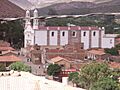
A view of Camargo, Bolivia.
See Also
 In Spanish: Camargo (Bolivia) para niños
