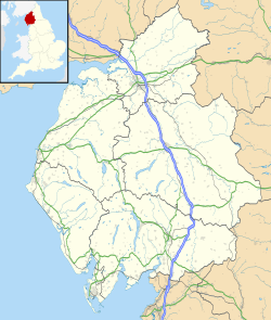
Camboglanna facts for kids
Quick facts for kids Camboglanna |
|
|---|---|
| Known also as | Castlesteads |
| Location | |
| Coordinates | 54°57′54″N 2°45′40″W / 54.965°N 2.761°W |
| County | Cumbria |
| Country | England |
| Reference | |
| UK-OSNG reference | NY514635 |
Camboglanna, known today as Castlesteads, was an important Roman fort. It was the twelfth fort along Hadrian's Wall, counting from the east. This fort was located between Banna (modern Birdoswald) to the east and Uxelodunum (modern Stanwix) to the west.
Camboglanna was built about 7 miles (11 km) west of Birdoswald. It sat on a high cliff that looked over the Cambeck Valley. This location was perfect for guarding an important path leading to Hadrian's Wall. It also helped watch the east bank of the Cambeck river, protecting against raiders from the Bewcastle area.
Sadly, much of the fort was flattened in 1791. This happened when the gardens of Castlesteads House were built over the ancient site. The name "Camboglanna" is thought to mean "Crook Bank" or "Bent Valley." This is because it overlooks a bend in the River Irthing. The name comes from an old British language. Cambo- means "curved" or "bent," and glanna means "steep bank" or "valley with a stream."
For a while, people thought Camboglanna was the Roman name for Birdoswald. But now, experts believe this was a mistake in an old Roman document called the Notitia Dignitatum. The Roman name for Birdoswald is now thought to be Banna.
What Did the Fort Look Like?
The fort was roughly square-shaped. It measured about 400 feet (120 meters) by 400 feet (120 meters). This covered an area of about 3.75 acres (1.5 hectares). The fort faced mostly north-west by south-east. It overlooked the deep valley of the Cambeck river. Over time, the river's erosion has destroyed the north-west side of the fort.
Camboglanna is unique because it was built inside the Vallum. The Vallum was a large ditch and earthwork system that ran parallel to Hadrian's Wall. Most forts were built right next to the Wall. It seems the Wall was already built at the best place to cross the Cambeck. So, when the fort was added, the Romans chose the strongest defensive spot, even if it wasn't right next to the Wall.
Who Lived at the Fort?
Different groups of Roman soldiers were stationed at Camboglanna over the years.
- In the 2nd century, the fort was home to the First Cohort of Batavians. These were soldiers from a region now in the Netherlands.
- Later, the Cohors IV Gallorum equitata took over. This was a unit of Gauls, who were from what is now France. Equitata means they were partly mounted (they had cavalry).
- In the 3rd century, the Cohors II Tungrorum was stationed here. These soldiers were from a region in modern-day Belgium. They were also a part-mounted unit.
Exploring the Fort: Excavations
Archaeologists have dug up parts of the fort to learn more about it.
- In 1934, parts of the fort were excavated. The walls were uncovered, except for the missing north-west wall.
- They also found the double gates on the north-east and south-west sides.
- A tower at the southern corner of the fort was also uncovered.
- It was discovered that the fort was protected by a single ditch around its outside.
- Several altars, which are stone structures used for religious offerings, have been found at the site. These altars have been carefully preserved.
Even earlier, in 1741, a local historian named Susanna Appleby found and partly dug up an external bath-house. This was a building outside the fort where soldiers could bathe.
 | Charles R. Drew |
 | Benjamin Banneker |
 | Jane C. Wright |
 | Roger Arliner Young |


