
River Irthing facts for kids
Quick facts for kids Irthing |
|
|---|---|

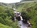
Crammel Linn waterfall
|
|
| Country | United Kingdom |
| Constituent country | England |
| Physical characteristics | |
| Main source | Paddaburn Moor |
| River mouth | confluence with River Eden |
The River Irthing is a river in Cumbria, England. It is a major tributary of the River Eden. For its first 15 miles, the river forms the border between Northumberland and Cumbria.
Contents
Where Does the River Irthing Flow?
The River Irthing starts on Paddaburn Moor in Kielder Forest. It flows around the edge of Butterburn Flow, which is a type of raised bog. Along the upper parts of the river, people have found remains of old shelters called shielings. These shelters were used by shepherds in the Middle Ages.
The Irthing Gorge and Waterfalls
For about two miles, the river flows through a deep valley called the Irthing Gorge. This gorge has tall cliffs made mostly of sandstone. In the upper part of the gorge, you can see the amazing Crammel Linn waterfall. This waterfall is about 7.6 meters (25 feet) high.
Near the waterfall, you might spot Peregrine falcons and ravens. They often build their nests there. Further downstream, near the Gilsland Spa hotel, the cliffs become even higher. Below the hotel, there are special springs. One is a sulphurous spring, which gives the hotel its name. There is also a chalybeate spring and a petrifying seep.
How the Landscape Changed
Scientists believe that before the last Ice Age, the Irthing flowed into the South Tyne valley. This area is now known as the Tyne Gap. However, a lot of glacial till (rock and dirt left by glaciers) blocked the old path. This forced the river to flow southwest instead.
You can see how much the landscape is still changing. The cliffs near Birdoswald Roman Fort are eroding quickly. Also, the old Roman bridge at Willowford is now much further from the river than it used to be. This shows how the land is still recovering from the Ice Age.
The River Irthing and Roman History
Hadrian's Wall once crossed the River Irthing on a bridge at Willowford. This spot is about 0.75 kilometers (0.5 miles) east of Birdoswald Roman Fort. As the river turns west from this point, you can find other Roman sites. These sites are connected to the Roman Stanegate road and Hadrian's Wall.
A long section of Hadrian's Wall, about 914 meters (2,998.7 feet), runs along the River Irthing at Willowford. This section includes two turrets and impressive remains of the old Roman bridge. A new footbridge now connects this area to Birdoswald Roman Fort. The way Hadrian's Wall was built here shows that there was more building stone available to the east.
Where the Irthing Ends
After passing Brampton, the River Irthing joins with the River Gelt. Soon after, it meets the River Eden near Warwick Bridge, just north of Wetheral.
Images for kids
-
Crammel Linn waterfall
