
Stanegate facts for kids
Quick facts for kids
[[File:|175x70px|alt= shield]] Stanegate |
|
|---|---|
| Roman Road | |

Route of the Stanegate
|
|
| Route information | |
| Length | 38 mi (61 km) |
| Time period | Roman Britain |
| Major junctions | |
| From | Corstopitum |
| Vindolanda, Magnis | |
| To | Luguvalium |
| Road network | |
|
|
The Stanegate was an important Roman road in what is now northern England. Its name means "stone gate" or "stone road". This ancient road connected two important Roman forts. These were Corstopitum (today's Corbridge) in the east and Luguvalium (today's Carlisle) in the west.
The Stanegate followed the natural path of the River Tyne and River Irthing valleys. It was built many years before Hadrian's Wall. Hadrian's Wall later followed a path very similar to the Stanegate, but a little further north.
It's important not to confuse the Stanegate with other Roman roads called Stane Street in southern England. These roads also had names meaning "stone road."
Unlike most Roman roads, the Stanegate often followed easier slopes. It would curve and weave instead of going in a straight line. Most Roman roads were built very straight, even if it meant climbing steep hills.
Today, a large part of the Stanegate is still used as a modern road. You can find it between Fourstones and Vindolanda in Northumberland.
Contents
History of the Stanegate
Historians believe the Stanegate was built between 77 and 85 AD. This was when Agricola was governor, during the time of emperors Vespasian, Titus, and Domitian.
Why the Stanegate Was Built
The Stanegate was first built as a strategic road. This means it was used for moving troops and supplies. At that time, the Roman frontier was much further north, along the Forth and Clyde in Scotland.
Later, the Romans pulled back from Scotland. The Stanegate then became part of the new Roman frontier.
Forts Along the Road
When it was a strategic road, forts were built along the Stanegate. These forts were about 14 Roman miles apart. This was a good distance for a day's march. Early forts like Vindolanda, Nether Denton, Corstopitum, and Luguvalium were built around 70-80 AD.
When the Stanegate became the frontier, more forts were added. These new forts were about half a day's march apart. They included Newbrough, Magnis (Carvoran), and Brampton Old Church. This strengthening of the defenses happened around 105 AD.
How the Stanegate Was Built
The Stanegate was a well-built road. Near Corstopitum, it was about 22 feet (6.7 meters) wide. It had stone gutters to drain water. The road's base was made of 6 inches (150 mm) of small stones called cobbles. On top of this, there were 10 inches (250 mm) of gravel.
The Route of the Stanegate
The Stanegate started in the east at Corstopitum (Corbridge). This was also where another important road, Dere Street, headed north towards Scotland.
Eastern Section of the Road
West of Corstopitum, the Stanegate crossed the Cor Burn. It then followed the north bank of the River Tyne. It reached the North Tyne near the village of Wall. A Roman bridge must have crossed the North Tyne here.
From there, the road went west past Fourstones to Newbrough. This was the first fort, about 7.5 miles from Corbridge.
Middle Section of the Road
From Newbrough, the Stanegate continued west. It ran parallel to the South Tyne. It then reached the major fort of Vindolanda (Chesterholm).
After Vindolanda, the Stanegate crossed the path of the modern Military Road. It passed just south of the smaller fort of Haltwhistle Burn. The road then continued west, away from the South Tyne. It passed the major fort of Magnis (Carvoran). This was about 6.5 miles from Vindolanda. At Magnis, the Stanegate met the Maiden Way road, which came from the south.
Western Section of the Road
From Magnis, the road turned southwest. It followed the River Irthing. It passed the smaller fort of Throp. Then it reached the major fort of Nether Denton. This was about 4.5 miles from Magnis.
From Nether Denton, the road kept following the River Irthing. It headed towards modern Brampton. It passed the smaller fort of Castle Hill Boothby. Then, about 1 mile west of Brampton, it reached the major fort of Brampton Old Church. Half of this fort is buried under Old St Martin's church.
From Brampton Old Church, the road crossed the River Irthing. It continued southwest through Irthington and passed through what is now Carlisle Airport. You can even see the curve of an old Roman marching camp from the air near the airport runway.
The Stanegate then went through a large cut in High Crosby. Finally, it crossed the River Eden near the cricket ground in modern Carlisle. It ended at the fort of Luguvalium (Carlisle), where Carlisle Castle now stands. This was about 7.5 miles from Brampton Old Church.
Some people think the road might have gone even further west. It might have reached the Roman fort at Kirkbride, overlooking Moricambe Bay. However, there isn't enough proof for this.
There's also a suggestion that the Stanegate might have gone east from Corstopitum. It could have linked to Pons Aelius (modern Newcastle upon Tyne). But again, no evidence has been found yet.
Important Forts Along the Stanegate
Here is a list of the main Roman forts and smaller forts found along the Stanegate:
- Corstopitum (Corbridge) – a major fort
- Newbrough – a minor fort
- Vindolanda (Chesterholm) – a major fort
- Haltwhistle Burn – a minor fort
- Magnis (Carvoran) – a major fort
- Throp, near Gilsland – a minor fort
- Nether Denton – a major fort
- Castle Hill Boothby, between Brampton and Lanercost Priory – a minor fort
- Brampton Old Church – a major fort
- Luguvalium (Carlisle) – a major fort
Later History of the Stanegate
Much of the Stanegate became the base for a medieval road called the Carelgate (or Carlisle Road). This road ran from Corbridge market place. Over time, the Carelgate became so bad that coaches and wagons could not use it.
In 1751–1752, a new Military Road was built. This was done by General George Wade after the Jacobite rising of 1745.
Images for kids
-
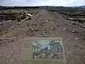
The Stanegate road inside the Corbridge Roman Site.
-
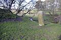
A Roman milestone next to the Stanegate near Vindolanda.


See also
 In Spanish: Stanegate para niños
