Camilo Ponce Enríquez (parish) facts for kids
Quick facts for kids
Camilo Ponce Enríquez
|
|
|---|---|
|
Parish and town
|
|
 |
|
| Country | |
| Province | Azuay |
| Canton | Camilo Ponce Enríquez |
| Named for | Camilo Ponce Enríquez |
| Area | |
| • Parish and town | 214.6 km2 (82.9 sq mi) |
| • Town | 2.2 km2 (0.8 sq mi) |
| Elevation | 362 m (1,188 ft) |
| Population
(2022 census)
|
|
| • Parish and town | 22,810 |
| • Density | 106.29/km2 (275.29/sq mi) |
| • Town | 10,015 |
| • Town density | 4,550/km2 (11,790/sq mi) |
| Climate | Aw |
Camilo Ponce Enríquez is a special place in southern Ecuador. It is both a parish (like a small district) and a town. This area is part of the Azuay province.
The town is the main center of the Camilo Ponce Enríquez canton. It is located about 230 miles southwest of Quito. Quito is the capital city of Ecuador.
Contents
Who Was Camilo Ponce Enríquez?
The town and canton are named after a very important person. His name was Camilo Ponce Enríquez (1912–1976). He was a politician who served as the president of Ecuador. He was president from 1956 to 1960.
What is Camilo Ponce Enríquez Like?
This area covers about 214.6 square kilometers. That's about 83 square miles. The town itself is smaller, covering about 2.2 square kilometers.
How Many People Live There?
According to the 2022 census, about 22,810 people live in the entire parish. In the main town, there are about 10,015 residents.
What is the Climate Like?
Camilo Ponce Enríquez has a tropical savanna climate. This means it's generally warm all year round. It also has distinct wet and dry seasons.
Natural Beauty
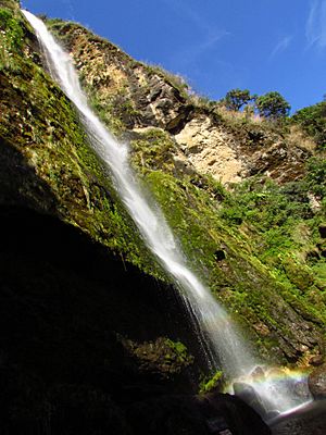
The area is known for its natural beauty. You can find beautiful waterfalls and green landscapes. This makes it a great place to explore nature.
See also
 In Spanish: Camilo Ponce Enríquez (ciudad) para niños
 | Stephanie Wilson |
 | Charles Bolden |
 | Ronald McNair |
 | Frederick D. Gregory |


