
Campo Indian Reservation facts for kids
 |
|
| Total population | |
|---|---|
| 351 reservation residents | |
| Regions with significant populations | |
| United States (California) | |
| Languages | |
| Kumeyaay, Tipai English | |
| Religion | |
| Traditional tribal religion, Christianity (Roman Catholicism) |
|
| Related ethnic groups | |
| other Kumeyaay people, Cocopa, Quechan, Paipai, and Kiliwa |


The Campo Indian Reservation is the home of the Campo Band of Diegueño Mission Indians. They are also known as the Campo Kumeyaay Nation. This is a federally recognized tribe of Kumeyaay people located in the southern Laguna Mountains of eastern San Diego County, California. The reservation was started in 1893 and covers about 16,512 acres (66.82 km2) of land.
You can find the reservation in southeastern San Diego County, high up in the Laguna Mountains. It began with 710 acres in 1893. More land was added later, including 80 acres in 1907 and a large area of 13,610 acres in 1911. All the land on Campo is owned by the tribe. The Campo Valley was called Meelqsh G'tay in the Kumeyaay language, which means "big open meadow." It was also known by its Spanish name, "Milguatay."
Contents
A Look Back: History of the Campo Kumeyaay
How the Kumeyaay Lived Before Contact
The Kumeyaay Nation's land stretched from the northern parts of modern San Diego County to the western edges of the Imperial Valley and the northern tip of Baja California, Mexico. There were many different groups, or clans, within the Kumeyaay nation. The Campo, or Meelqsh G'tay, were one of these clans. These clans would often work together, especially when they faced threats from other groups.
Challenges After European Contact
The Campo people and their neighboring clans stood strong against the Spanish missionaries and soldiers. The Mission Basilica San Diego de Alcala, founded in 1769, caused many problems for the tribe. This led to several revolts. One of the most famous was the attack and destruction of the San Diego Mission in 1775.
After the Mexican Revolution, the new Mexican government changed the Mission system. Most Missions became large farms where many Native American tribes were forced to work. In response, several Native American revolts and raids in the area caused damage to many of these farms. By 1842, the farms were left empty, and warriors began attacking the city of San Diego. However, the city was not destroyed.
The Mexican-American War also affected the Kumeyaay when U.S. forces arrived in San Diego. The Kumeyaay offered their support, but U.S. forces told them to stay out of the fighting. This led to an agreement about land in the Treaty of Santa Ysabel. However, the United States Senate did not approve this treaty.
Because of military conflicts, efforts to stop raids, and people moving in due to the gold rush, the number of Native Americans in California dropped by 90% between 1850 and 1860. After 1870, the Kumeyaay's land began to be divided into sections, which later became reservations. The first part of the Campo Indian Reservation was established in 1893.
The Modern Era for the Campo Tribe
Over time, the Treaty of Santa Ysabel and similar treaties were found to have been kept secret. In 1927, supporters of the Mission Indian Federation, a group that helped Native American rights, had a conflict with the Bureau of Indian Affairs police on the Campo Indian Reservation.
Later in the 20th century, the Campo Indian Reservation saw some positive changes. These included public assistance and food programs in the 1960s. The Self Determination Act of 1975 gave tribes more control over their own affairs. By 1978, the Campo people set aside an area for economic development. Since then, the tribe has built a casino and a wind farm.
What Services Does the Campo Tribe Offer?
In 1990, the Campo Band created the Campo Environmental Protection Agency (CEPA). This agency works to protect the environment and public health as new businesses are developed. The tribe also has the Campo Indian Education Center and the Campo Tribal Training Program.
The Campo Kumeyaay Nation gets health services from the Southern Indian Health Council.
Understanding the Land: Topography
The Campo Indian Reservation includes two main areas. The main office for the tribal government is in the northern part of the reservation, near Campo and Cameron Corners. This area is roughly one mile across on each side.
A second, larger part of the Campo Indian Reservation is located to the east, near Live Oak Springs. This area is shaped like a rectangle. It is about six miles (10 km) from north to south and about 3.2 miles (5.1 km) from east to west. Live Oak Springs is located at 32°41′26″N 116°20′01″W / 32.69056°N 116.33361°W. The southern edge of this area is about 0.4 miles (0.64 km) north of the Mexican border.
How the Campo Tribe Builds Its Economy
Muht Hei, Inc. is the tribe's business company. It manages the Golden Acorn Casino, Campo Materials, and Kumeyaay Wind. Kumeyaay Wind is a wind farm with 25 large wind turbines. The tribe owns and runs the Golden Acorn Casino, the Golden Grill Restaurant, the Del Oro Deli, and a travel center, all located in Campo. The 50 MW wind farm creates enough power to supply about 30,000 homes each year. It also helps reduce greenhouse gas emissions by about 110,000 tons annually.
A larger project is planned for the area. This project would cover 1,000 acres and include 48 to 60 bigger turbines. These new turbines would connect to the 500 kV Sunrise Powerlink. For nearly 200 days and nights each year, the average wind speed in the area is good for producing power.
Staying Connected: Internet Access
Some parts of this remote area have wireless internet access for tribe members. This service is provided through the Tribal Digital Village, which is based on the Pala Indian Reservation, about 80 miles (130 km) north. This effort has been featured in news articles and on television programs.
Learning and Education
The Mountain Empire Unified School District serves the reservation.
Images for kids
-
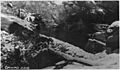
Campo Reservation Dam, around 1920

