Cantref of Penfro facts for kids
The Cantref of Penfro was a special area in ancient Wales, like a county or district. It was one of seven such areas in the old Kingdom of Dyfed. Later, around the year 950, it became part of another Welsh kingdom called Deheubarth.
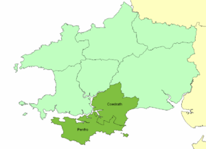
This cantref was located in the long, narrow part of Wales that sticks out into the sea, south of the Eastern Cleddau and the Daugleddau estuary. On its land side, it was next to another cantref called Cantref Gwarthaf. The name "Penfro" means "land's end." It comes from the Welsh words Pen (meaning "end" or "head") and fro (meaning "populated area"). The Cantref of Penfro covered about 140 square miles (360 square kilometers).
How Penfro Was Organized
The Cantref of Penfro was divided into two smaller areas called commotes. Think of a commote as a smaller district within a county. These two commotes were:
- Cwmwd Penfro, in the southwest.
- Cwmwd Coedrath, in the northeast.
The main town for the Cantref of Penfro was Pembroke. It was the civil headquarters, meaning where the local government was based. Some historians think that Rhoscrowther or Penally might have been important religious centers for the area.
Norman Influence and Castles
In the 12th century, the Cantref of Penfro became part of the Norman lands in Wales, known as the March. The Normans were a powerful group who built many strong castles to control the land.
Many famous castles were built in this area, including:
Because of the Norman influence, the area around Penfro became English-speaking. Most people there still speak English today, except for a small part in the north of Narberth parish.
Changes Over Time
In 1535, a set of laws called the Acts of Union changed how Wales was governed. The Cantref of Penfro was split up and became part of new areas called hundreds.
- Cwmwd Penfro became the Castlemartin Hundred.
- Cwmwd Coedrath was joined with the Narberth Hundred.
These changes helped shape the map of Wales into what we know today.
 | Aurelia Browder |
 | Nannie Helen Burroughs |
 | Michelle Alexander |


