Cape May Point State Park facts for kids
Quick facts for kids Cape May Point State Park |
|
|---|---|

|
|
| Lua error in Module:Location_map at line 420: attempt to index field 'wikibase' (a nil value). | |
| Location | Lower Township |
| Area | 244 acres (0.99 km2) |
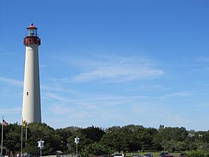
Cape May Point State Park is a super cool place to explore in New Jersey! It's a big park, about 244 acres (that's like 185 football fields!), located in Lower Township, New Jersey. Here, you can walk, hike, and discover nature on special trails. The park also has beautiful beaches, a fun exhibit gallery, and a ranger office where you can learn more. It's also home to the famous Cape May Lighthouse. The New Jersey Division of Parks and Forestry takes care of this amazing park.
Contents
Why is Cape May Point State Park Great for Bird Watching?
Cape May Point State Park is one of the best spots in North America to see birds, especially during their Fall migration south. This means that watching birds, also called birding, is a very popular activity here!
Every fall, people come from all over the country to watch thousands of birds fly south for the winter. It's an amazing sight! There's even a special "hawk watch" where experts count different types of hawks and other birds of prey over several months.
Where Can You Spot Birds in the Park?
You can see many different kinds of birds in three main areas of the park:
- The hawk watching platform is perfect for spotting hawks.
- The nature and hiking trails are great for seeing songbirds.
- The beach is where you'll find shorebirds.
You can usually see many types of birds in all these areas throughout the year, not just during migration!
Explore the Trails at Cape May Point State Park
The park has three awesome hiking trails, and each one is marked with a different color. All the trails start and end at the parking lot, making them easy to find.
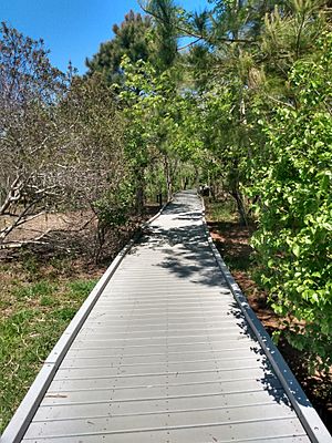
- The Red Trail is about 0.5 miles (0.8 km) long. It's a boardwalk trail, which means it's easy to walk on and is even friendly for wheelchairs. Along this trail, you'll find several platforms where you can stop and enjoy the views.
- The Yellow Trail is a bit longer, about 1.5 miles (2.4 km). It's a mix of boardwalk and dirt paths. This trail branches off from the Red Trail and has an extra platform for bird watching.
- The Blue Trail is the longest at 2.0 miles (3.2 km). It was closed for a long time after a big hurricane in the 1960s, but it reopened in the 1990s. Part of this trail takes you right along the beach!
Discovering History: Old Military Sites
Did you know that during World War I and World War II, this park was a military base called the Cape May Military Reservation? Today, you can still see parts of the old gun batteries that were used to protect the coast.
What Are These Old Structures?
During World War II, there were three main gun areas in the park. One of these was called Battery 223. It had two large 6-inch guns and a special underground bunker between them that stored ammunition and helped control the guns.
Today, only the bunker for Battery 223 is still visible. It looks like a concrete structure, but its original earth cover is gone. Other old military spots were covered up during a beach restoration project in 2005. It's cool to think about the history hidden right here in the park!
Images for kids
 | Ernest Everett Just |
 | Mary Jackson |
 | Emmett Chappelle |
 | Marie Maynard Daly |


