
Cape Tormentine, New Brunswick facts for kids
Cape Tormentine is a small community in southeastern New Brunswick, Canada. It sits right on the coast, facing the Northumberland Strait. This spot is special because it's the shortest distance between mainland Canada and Prince Edward Island (PEI). For many years, Cape Tormentine was a very busy place. It was a major hub for travel and shipping between New Brunswick and PEI.
The community is named after the cape it sits on. Its name comes from the French word "tourmentin," which means "stormy." This name likely refers to the often rough waters around the cape. Today, Cape Tormentine is much quieter. Its role as a travel hub ended in 1997 when the Confederation Bridge opened. This bridge connects PEI directly to the mainland, making the ferry service from Cape Tormentine no longer needed.
Contents
A Busy Crossing Point
For a long time, Cape Tormentine was the main gateway to Prince Edward Island. People and goods traveled across the water here. This section explains how this important connection changed over the years.
Early Travel: Iceboats and Ferries
- 1827: Travel across the Northumberland Strait began with special iceboats. These boats could cross the ice and water to Cape Traverse on PEI. This route was known as the Capes Route.
- 1873: When PEI joined Canada, the government promised to provide "continuous steamship service." This meant keeping the iceboats running and adding steamships.
- 1886: A railway line, the New Brunswick and Prince Edward Island Railway, reached Cape Tormentine. This connected the community to the main railway network in Canada. Now, trains could bring people and goods right to the ferry docks.
The Age of Train Ferries
- 1917: The iceboats were replaced by a powerful new ship called the SS Prince Edward Island. This was an ice-breaking train ferry. It was built in England and could cut through thick ice. It was also big enough to carry 12 railway cars! A new port was built just for this large ferry.
- 1947: The SS Prince Edward Island was replaced by an even bigger ferry, the MV Abegweit. This ship was 113 meters (372 feet) long and weighed 7,000 tons. It had powerful engines and could carry 950 passengers and 60 cars. It could even carry a whole passenger train with 16 railway cars!
- 1968: Another ferry, the MV John Hamilton Gray, joined the route to help with the growing number of travelers.
- 1982: A brand new Roll-on/roll-off ferry, also named the MV Abegweit, took over. This was a huge ship, 122 meters (401 feet) long and weighing 12,000 tons. It could carry 974 passengers and 250 cars. It was also big enough for 40 large trucks or 20 railway cars.
The End of an Era
- 1989: The last train arrived at Cape Tormentine on New Year's Eve. The railway line to PEI and the branch to Sackville closed down. This old railway path is now a walking and biking trail.
- 1997: The ferry service from Cape Tormentine officially ended. This happened because the Confederation Bridge opened nearby. The bridge provided a direct road link to PEI, making the ferry unnecessary. While the Cape Tormentine ferry service stopped, another ferry company, Northumberland Ferries Limited, still operates a service between Wood Islands, PEI, and Caribou, Nova Scotia.
Images for kids
-
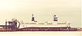
The MV Abegweit ferry at Cape Tormentine in 1996.
-

The former train station and lighthouse at Cape Tormentine.


