Northumberland Strait facts for kids
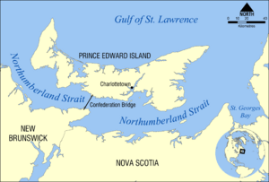
The Northumberland Strait is a narrow stretch of ocean in eastern Canada. It's like a watery passage that connects the Gulf of Saint Lawrence to the wider Atlantic Ocean. This strait is found between Prince Edward Island and the coasts of New Brunswick and Nova Scotia.
It's known for having some of the warmest ocean water in Canada during the summer!
Contents
Where is the Northumberland Strait?
The Northumberland Strait has clear boundaries. On the western side, it stretches from North Cape, Prince Edward Island to Point Escuminac, New Brunswick. On the eastern side, it goes from East Point, Prince Edward Island to Inverness, Nova Scotia.
Water Features
The strait's depth changes quite a bit, from about 17 to 65 meters (56 to 213 feet). The deepest parts are at each end.
The tides here are interesting. The eastern end has two tides each day, like most places. The water level can change by 1.2 to 1.8 meters (about 4 to 6 feet). But the western end usually has only one main tide per day.
Because the water is not very deep, it gets very warm in the summer. Some areas can reach 25°C (77°F). This makes it the warmest ocean water in Canada, and one of the warmest on the Atlantic coast north of Virginia.
Many sandy beaches line the coasts of the strait in New Brunswick, Prince Edward Island, and Nova Scotia. These beaches are very popular with people visiting the area.
In winter, from December to April, the entire strait and the Gulf of St. Lawrence are covered in sea ice.
Land and Rocks
The land around the central and western parts of the strait, including the south shore of Prince Edward Island, is mostly made of sandstone. This is why there are so many beautiful sandy beaches here. The western parts of Cape Breton Island and northeastern Nova Scotia peninsula have granite rocks.
The biggest island in the strait is Pictou Island.
Towns and Cities
Many communities are located along the Northumberland Strait. These include the cities of Charlottetown and Summerside on Prince Edward Island. Other towns are Souris, Prince Edward Island, Pictou, Nova Scotia, and Shediac, New Brunswick.
Getting Around

People use different ways to travel across or along the strait.
Shipping and Boats
The Northumberland Strait is a smaller route for ships. Ports like Pugwash ship salt. Summerside, Charlottetown, Georgetown, and Souris send out farm products and receive oil and building materials. Pictou ships wood products. Shipping has become less common because highways now connect to bigger ports outside the strait, which freezes in winter.
Large cruise ships often visit Charlottetown in summer and fall. Since 2012, some smaller cruise ships have also started visiting Pictou, Nova Scotia.
Confederation Bridge
The narrowest part of the strait is called the Abegweit Passage. It's about 13 kilometers (8 miles) wide. This is where the Confederation Bridge now stands. It connects Borden-Carleton, Prince Edward Island to Cape Jourimain, New Brunswick.
Ferries
Three ferry services operate on the strait during the warmer months (May to December), when there is no ice:
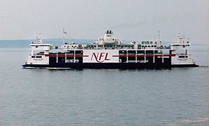
- Northumberland Ferries Limited carries passengers and vehicles between Caribou, Nova Scotia and Wood Islands, Prince Edward Island.
- A ferry for passengers only goes from Caribou, Nova Scotia to Pictou Island.
- Groupe CTMA offers a passenger and vehicle service between Souris, Prince Edward Island and Cap-aux-Meules, Quebec.
Before the Confederation Bridge opened in 1997, there was a ferry service that ran all year round. It connected Port Borden, Prince Edward Island and Cape Tormentine, New Brunswick. This ferry was very busy and was replaced by the bridge.
Undersea Cables
Special cables run under the strait to help connect Prince Edward Island to the mainland.
- Electricity
Maritime Electric provides electricity to Prince Edward Island. Most of this power comes from NB Power in New Brunswick. Two large electrical cables were laid under the strait between Murray Corner, New Brunswick and Fernwood, Prince Edward Island in the 1970s. These cables were designed to be safe from ice in winter. They were replaced with two new, more powerful cables in 2017.
Pictou Island does not get electricity from Nova Scotia. People living there have to make their own power.
- Telecommunications
Bell Aliant has two fibre optic cables under the strait for phone and internet services to Prince Edward Island. One runs from Caribou, Nova Scotia to Wood Islands, Prince Edward Island. The other runs through the Confederation Bridge.
Eastlink also has a fibre optic cable connecting Gaspereau, Prince Edward Island with Port Hood, Nova Scotia.
Swimming Across the Strait
Many people have tried to swim across the Northumberland Strait. Most of these swims have happened at the western end, across the Abegweit Passage.
The first recorded swim across the Abegweit Passage (about 14 kilometers or 8.7 miles) was by Evelyn Henry on July 15, 1951. She swam from Cape Tormentine, New Brunswick to Borden, Prince Edward Island in 8 hours and 47 minutes.
Two people have even swum across and back (a double crossing, about 27 kilometers or 16.8 miles) in one day:
- Jennifer Alexander swam a double crossing on July 26, 2007, in 19 hours, 17 minutes.
- Kristin Roe swam a double crossing on July 26, 2008, in 15 hours, 40 minutes.
The first recorded swim across the eastern end of the strait (about 24.5 kilometers or 15.2 miles) was by Jill Leon on July 31, 2013. She swam from Caribou, Nova Scotia to Wood Islands, Prince Edward Island in 9 hours, 48 minutes.
Stories and History
The strait is famous for a local legend called the Ghost Ship of Northumberland Strait. People say they sometimes see a flaming ship appearing in the middle of the strait.
The strait is also known for "ice boats." These were small boats with oars that people used to cross the strait in winter. They carried mail and passengers, and it was a very dangerous journey before ice breaking ferries were used.
Images for kids
-
Northumberland Strait with MV Holiday Island, Pictou Island in background
See also
In Spanish: Estrecho de Northumberland para niños
 | Misty Copeland |
 | Raven Wilkinson |
 | Debra Austin |
 | Aesha Ash |


