Point Escuminac facts for kids
 |
|
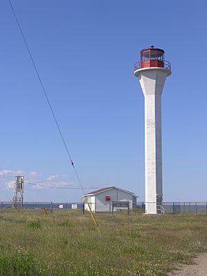
| Lighthouse at Point Escuminac, Miramichi Bay, New Brunswick | |
| Location | Point Escuminac New Brunswick Canada |
|---|---|
| Coordinates | 47°4′22.86″N 64°47′52.51″W / 47.0730167°N 64.7979194°W |
| Year first constructed | 1841 (first) |
| Year first lit | 1966 (current) |
| Automated | 1989 |
| Deactivated | 1966 (first) |
| Foundation | concrete base |
| Construction | concrete tower (current) wooden tower (first) |
| Tower shape | hexagonal prism with flared top supporting balcony and lantern (current) octagonal prism tower (first) |
| Markings / pattern | white tower, red lantern (current) white tower (first) |
| Height | 22 metres (72 ft) (current) |
| Focal height | 22.2 metres (73 ft) (current) 21.3 metres (70 ft) (first) |
| Range | 13 nautical miles (24 km; 15 mi) |
| Characteristic | Fl W 3s. |
| Fog signal | two 3s. blast every 60s. |
| Admiralty number | H1424 |
| CHS number | CCG 1163 |
| NGA number | 7580 |
| ARLHS number | CAN-389 |
Point Escuminac is a piece of land that sticks out into the water in eastern New Brunswick, Canada. It's like a natural border that helps mark the western edge of the Northumberland Strait. This area is close to a small fishing community called Escuminac, right where the Miramichi Bay meets the sea.
Contents
Discovering Point Escuminac
Point Escuminac is located in a beautiful coastal area. Its exact spot is 47 degrees North and 64 degrees West. This cape is important because it acts as a dividing line. It shows where the Northumberland Strait officially begins on its western side.
The Point Escuminac Lighthouse
A very important building at Point Escuminac is its lighthouse. Lighthouses are tall towers with bright lights. They help ships find their way safely, especially at night or in bad weather. The lighthouse at Point Escuminac guides boats entering or leaving Miramichi Bay.
A Look at the Lighthouse's Past
The very first lighthouse at Point Escuminac was built in 1841. It was made of wood and looked like an eight-sided tower. This original lighthouse was used for many years.
The lighthouse you see today is not the first one. It was built in 1966. This newer lighthouse is made of strong concrete. The first lighthouse was turned off when the new one started working.
How the Lighthouse Works Today
The current lighthouse is 22 meters (about 72 feet) tall. It has a white tower and a red top where the light shines. The light flashes white every three seconds. This pattern helps sailors know it's the Point Escuminac Lighthouse.
In 1989, the lighthouse became automated. This means machines now control it, and people don't need to live there to operate it. It also has a fog signal that makes two three-second blasts every minute. This helps ships when it's foggy and they can't see the light.
 | Jessica Watkins |
 | Robert Henry Lawrence Jr. |
 | Mae Jemison |
 | Sian Proctor |
 | Guion Bluford |

