
Cape Jourimain facts for kids
Quick facts for kids Cape Jourimain |
|
|---|---|

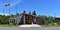
Entry pavilion at the Cape Jourimain Nature Centre
|
|
| Lua error in Module:Location_map at line 420: attempt to index field 'wikibase' (a nil value). | |
| Location | Bayfield, New Brunswick, Canada |
| Area | 621 hectares (1,530 acres) |
| Website | https://www.capejourimain.ca/ |
Cape Jourimain is a special place in New Brunswick, Canada. It includes two islands and a piece of the mainland. This area is on the southwestern shore of the Northumberland Strait. It's about three kilometers west of Cape Tormentine.
The two islands, Jourimain and Trenholm, have been connected to the mainland since 1966. This connection was made by a human-built causeway. Cape Jourimain is famous as the old crossing point from New Brunswick to Prince Edward Island (PEI). Today, it's home to the western end of the Confederation Bridge. This bridge is Canada's longest fixed-link crossing.
In 1980, the two islands and part of the mainland became a National Wildlife Area (NWA). This means the area is protected for its wildlife. In 2001, the Cape Jourimain Nature Centre opened. It is run by a group that helps people learn about nature.
Contents
Cape Jourimain: A Historic Crossing Point
People have visited the Cape Jourimain area for at least 4,000 years. The Mi'kmaq people hunted animals like walrus and seals along the coast. They used canoes to cross the Northumberland Strait to PEI from here. Evidence shows that the Mi'kmaq did not live here permanently. They used it as a shared space because it was an important crossing point.
Early European Visits
Jacques Cartier landed on PEI in 1534. He thought it was the mainland and did not cross to the Jourimain Islands. The name Cape Tormentin was first used in 1672 by Nicolas Denys. He was a French merchant. He likely learned about the area from Mi'kmaq fishermen.
In the 1830s, the name Cape Tormentine moved to another community. The area then became known as the Jourimain Islands. Some people think "Jourimain" is a mistake for "germain." This is a French word meaning "sibling."
Changes to the Land
After the British defeated the French in the mid-1700s, new settlers arrived. These settlers came from New England. They began to settle areas like Sackville and Amherst. Around the early 1800s, they moved towards Bayfield and the Jourimain Islands.
During this time, the natural ecosystems of the Jourimain Islands changed a lot. This was because of a lot of farming in the area.
Crossing the Strait: Iceboats and Ferries
In 1827, the first winter crossing from Cape Traverse to Cape Jourimain happened. This route was easier than an older one. So, a deal was made for mail and passengers to cross between these two capes.
Special boats with runners were designed for crossing over ice. The journey was known for being very difficult. In the 1880s, the iceboat service moved to Cape Tormentine. By 1917, it stopped completely. This was because ferries could now break through ice.
The Allen Hotel and Lobster Industry
In 1811, Eliphalet and Hannah Allen built their home on Jourimain Island. They were among the first settlers after British rule. In 1827, they opened the Allen Hotel. It served the iceboat crews and passengers. Later, it also provided lodging for workers at a lobster cannery.
The cannery opened on Jourimain Island in the late 1800s. It was run by the Portland Packing Company. Many young Acadian women worked there.
The 1870s and early 1880s were a busy time for Cape Jourimain. The iceboat service, the Allen Hotel, and the lobster industry made it a busy place. But by the 1890s, things slowed down. A rail line to Cape Tormentine and a new pier were built. In 1905, the lobster cannery closed. This was due to fewer lobsters and more competition.
Cape Jourimain Lighthouse: A Guiding Light
In 1870, a 15.5-meter lighthouse was built at Cape Jourimain. It took almost 30 years of requests to get it built. The lighthouse helped sailors find their way in the narrow Strait. Lewis Wells looked after the lighthouse during its first winter.
The light started working in April 1871. On May 15, John Bent became the first permanent lighthouse keeper. His family kept the lighthouse for four generations.
In 1958, the light became fully automated. This meant Merrill Trenholm, the last lighthouse keeper, was no longer needed. The lighthouse kept working for another 39 years. It closed in 1997 when the Cape Tormentine ferry service stopped. This happened because the Confederation Bridge opened.
Saving the Lighthouse
In 2001, the Cape Jourimain Nature Centre started talking to the Government of Canada. They wanted to take care of the lighthouse. In 2015, they officially became its owners.
In 2016, the lighthouse was moved for the third time. This was to protect it from coastal erosion. In 2017, it was fully renovated. This work helped save the old structure from falling apart.
Cape Jourimain: A National Wildlife Area
In the 1960s, a causeway was built between the Jourimain Islands. This was part of a plan to build a fixed link to PEI. The plan was stopped, but the causeway remained. It cut the saltwater marshes in half. This created a brackish marsh. This new marsh became a great home for migrating ducks and other coastal wildlife.
In 1977, a plan was made to make Cape Jourimain a National Wildlife Area. In 1979, it officially became one. This 621-hectare area is managed by the Canadian Wildlife Service. It includes Jourimain Island, Trenholm Island, Oak Island, and part of the mainland. The main reason for protecting this area is to keep migrating birds, species at risk, and other wildlife safe. It also protects the ecosystems they need to survive.
The Confederation Bridge: Connecting Provinces
People had been talking about building a fixed-link to connect PEI to the mainland since the late 1800s. Early ideas included a railway tunnel under the Strait. But this idea was dropped because it was too difficult and expensive.
In the 1950s, a plan was suggested to build a causeway to PEI. In 1966, the Government of Canada started building it. They even built a causeway connecting Trenholm and Jourimain Island. But this project was also stopped because costs went too high. It wasn't until 1987 that the government started studying if a fixed-link crossing was possible.

In 1988, people in PEI voted on building a bridge. Most people voted yes. This meant the Cape Tormentine ferry service would close. The ferry had been running for almost a century. This caused a lot of concern in nearby communities. Many worried about losing local jobs.
Cape Jourimain in New Brunswick and Borden-Carleton in PEI were chosen as the bridge's ends. These spots are the shortest distance between the two provinces. In 1992, a company called Strait Crossing Joint Venture got the contract to build the bridge. Construction began in 1993.
The 12.9-kilometer cantilever bridge was finished in November 1996. It officially opened to the public on May 31, 1997. On opening day, 20,000 people attended a special run across the bridge. It is now a famous tourist attraction. It is known for being the longest bridge to cross ice-covered water.
Cape Jourimain Nature Centre: Learning About Nature

In 1997, the same year the Confederation Bridge opened, a group of experts and local landowners started the Cape Jourimain Nature Centre Incorporated. This group is a charitable nonprofit organization. Their goal is to offer eco-tourism and educational services to the public.
The organization was given permission to use a part of the National Wildlife Area. This area is near the Route 16 highway. They were allowed to build and run an eco-friendly facility. This facility includes an entry pavilion, an interpretive centre, a restaurant, and an observation tower. It also has a network of trails and other things for visitors. The centre officially opened in June 2001.
Images for kids
-
Entry pavilion at the Cape Jourimain Nature Centre
-

Cape Jourimain Lighthouse.
-
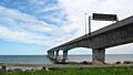
View of the Confederation Bridge from Gunning Trail.
-
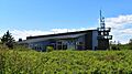
Cape Jourimain Interpretive Centre

