
Caribbean water resource region facts for kids
The Caribbean water resource region is one of 21 big areas that help scientists understand how water flows across the United States. Think of it like a giant map where each section shows where all the rain and rivers drain into. These areas are called "water resource regions" or "hydrologic units."
The Caribbean region has a special code, HUC 21, which helps identify it. It covers about 3,582 square miles (9,277 square kilometers). This region is made up of three smaller parts, or "subregions," each with its own special code (HUC 2101 to 2103).
This important water region includes:
- The Commonwealth of Puerto Rico.
- The United States Virgin Islands.
- Other smaller U.S. areas in the Caribbean Sea.
It covers all the land in these places where the United States has an interest or responsibility.

Contents
Exploring the Caribbean Water Subregions
The Caribbean water resource region is divided into three main subregions. Each subregion helps us understand the specific water systems in that area.
Puerto Rico Subregion (HUC 2101)
This subregion covers all the water systems and connected waters within the Commonwealth of Puerto Rico. It's the largest part of the Caribbean water resource region, covering about 3,480 square miles (9,013 square kilometers). This area is very important for managing the island's fresh water supply.
Virgin Islands Subregion (HUC 2102)
This part of the region includes all the water drainage and related waters within the United States Virgin Islands. It's much smaller than Puerto Rico, covering about 133 square miles (344 square kilometers). Even though it's small, managing water here is vital for the islands' communities and nature.
Caribbean Outlying Areas Subregion (HUC 2103)
This subregion includes water areas in other U.S. territories and interests in the Caribbean. It covers places like the Canal Zone, Navassa Island, and the Rancador and Serrana Banks. This subregion is about 650 square miles (1,683 square kilometers). It helps track water resources in these scattered but important locations.
Images for kids
-
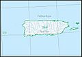
Map of the Puerto Rico subregion (HUC 2101).
-
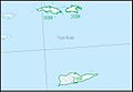
Map of the Virgin Islands subregion (HUC 2102).


