Carlisle, Western Australia facts for kids
Quick facts for kids CarlislePerth, Western Australia |
|||||||||||||||
|---|---|---|---|---|---|---|---|---|---|---|---|---|---|---|---|

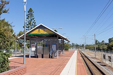
Carlisle railway station, before it was closed for upgrading
|
|||||||||||||||
| Postcode(s) | 6101 | ||||||||||||||
| Area | [convert: needs a number] | ||||||||||||||
| LGA(s) | Town of Victoria Park | ||||||||||||||
| State electorate(s) | Victoria Park | ||||||||||||||
| Federal Division(s) | Swan | ||||||||||||||
|
|||||||||||||||
Carlisle is a suburb located in Perth, Western Australia. It is part of the Town of Victoria Park local government area.
Contents
A Look Back: Carlisle's History
The area we know as Carlisle today was first settled after 1829. Large pieces of land were given to early settlers like Henry Camfield and James Macdermott. These land grants covered Carlisle and many nearby suburbs.
For many years, not much building happened, even with new owners. But after the 1890s, things changed. The nearby suburb of Victoria Park grew very quickly. This growth was mostly around Albany Road, which is now Albany Highway.
This growth eventually spread east. A real estate company called Peet and Co (now Peet Limited) started selling land for homes here. They called this new development "Bickford." On May 23, 1919, people living in the area voted to change the name to Carlisle.
The Bickford State School opened in 1919 and was renamed Carlisle Primary School in 1922. A Methodist church was built in 1927, followed by a Catholic church in 1937. Other important buildings and services soon followed.
Where is Carlisle? Its Geography
Carlisle is surrounded by several roads and landmarks. Orrong Road is to the north, and Briggs, Planet, and Kew streets are to the east. To the south, you'll find Rutland Avenue and the Armadale railway line. Roberts Road forms the western border.
Land and Hills
Carlisle is mostly flat, with some gentle slopes. It sits on a type of soil called "Bassendean Dunes" within the Swan Coastal Plain. The lowest point in Carlisle is about 13.3 meters (43.6 feet) above sea level. This spot is on Bishopsgate Street, near Koolbardi Park.
The highest point is about 27.1 meters (88.9 feet) above sea level. This is near the corner of Raleigh Street and Briggs Street. From the higher parts of Carlisle, you can sometimes see glimpses of the Perth CBD (city center) and Burswood buildings.
Streets and Trees
Carlisle's streets are laid out in a grid pattern. This was a common way to plan towns in early Perth. Most roads are about 20 meters (65 feet) wide. They usually have a footpath on at least one side, landscaped areas, and a road for cars about 7 meters (23 feet) wide. This allows for parking and cars to pass each other easily.
Many streets in Carlisle are lined with mature trees. Some common types you might see include:
- Lophostemon confertus (Queensland Box)
- Jacaranda mimosifolia
- Agonis flexuosa (Weeping Peppermint)
- Platanus acerifolia (London Plane)
- Callistemon vimnalis (Weeping Bottlebrush)
- Melaleuca saligna (Willow Bottlebrush)
- Melaleuca linarifolia (Snow in Summer)
- Celtis australis (European Nettle Tree)
- Ficus microcarpa (Chinese Banyan)
- Bauhinia purpurea (Purple Orchard Tree)
Places to Go: Facilities in Carlisle
Carlisle has five parks where you can relax or play: Fletcher Park, Carlisle Reserve, Parnham Park, Koolbardi Park, and Millers Crossing. The Carlisle Hotel and TAB are located across from the Carlisle train station.
Other important places include Holy Name Primary School, Lathlain Nursing Home, Windsor Park Nursing Home, and the Harold Hawthorne Seniors Centre. The Town of Victoria Park Council Depot and the City of Belmont Operations Centre are also in Carlisle.
Getting Around: Transport in Carlisle
Carlisle is well-connected by public transport. It has two train stations: Oats Street railway station and Carlisle railway station. Both stations are on the Armadale line and Thornlie line.
These stations are getting big upgrades as part of the Metronet project. The train tracks will be raised onto a concrete structure, making the stations more modern. Oats Street Station is also a major bus hub, where many bus routes connect.
Bus Routes
Here are some of the bus routes that serve Carlisle:
- Route 37: Travels from Curtin University Bus Station to Airport Central Station. It serves Oats Street.
- Route 38: Goes from Perth Busport to Cloverdale. It serves Archer Street and Carlisle Station.
- Route 39: Connects Elizabeth Quay Bus Station to Redcliffe Station. It serves Star Street and Oats Street.
- Route 51: Runs from Perth Busport to Cannington Station. It serves Orrong Road.
- Routes 282 and 283: Travel from Elizabeth Quay Bus Station to Kalamunda Bus Station. They serve Rutland Avenue.
- Route 284: Goes from Curtin University Bus Station to Belmont Forum. It serves Archer Street, Carlisle Station, and Star Street.
- Route 285: Connects East Victoria Park to Kewdale. It serves Oats Street and Orrong Road.
- Route 998 (CircleRoute Clockwise): A special route with limited stops that circles between Fremantle Station and other stations. It serves Orrong Road and Oats Street.
- Route 999 (CircleRoute Anti-Clockwise): The opposite direction of the CircleRoute, also with limited stops. It serves Oats Street and Orrong Road.
Train Lines
Carlisle is served by these train lines:
- Armadale/Thornlie Line
- Carlisle Station
- Oats Street Station
Learning Opportunities: Education
Carlisle is home to one college for further education. This is the South Metropolitan TAFE – Carlisle Campus, which offers vocational training.
 | Sharif Bey |
 | Hale Woodruff |
 | Richmond Barthé |
 | Purvis Young |

