Swan Coastal Plain facts for kids
Quick facts for kids Swan Coastal PlainSwan Coastal Plain scrub and woodlands |
|
|---|---|

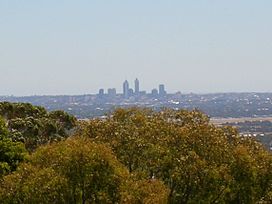
Swan Coastal Plain from Darling Scarp
|
|

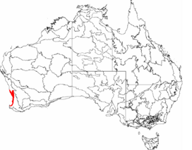
Map of IBRA regions with the Swan Coastal Plain in red
|
|
| Ecology | |
| Realm | Australasian |
| Biome | Mediterranean forests, woodlands, and scrub |
| Borders | East African montane forests |
| Geography | |
| Area | 15,280 km2 (5,900 sq mi) |
| Country | Australia |
| State | Western Australia |
| Conservation | |
| Conservation status | Critical/endangered |
The Swan Coastal Plain is a flat area of land in Western Australia. It is home to the Swan River, which flows west into the Indian Ocean. This coastal plain is much larger than just the Swan River area. It is an important geological and biological zone. It is also one of Western Australia's special natural regions.
Contents
Where is the Swan Coastal Plain?
This coastal plain is about 30 kilometers (19 miles) wide. It stretches along the Indian Ocean coast. To its east are the Darling Scarp uplands. The plain runs from Cape Naturaliste in the south to north of the city of Perth.
The land here is mostly sandy and not very fertile. It also has coastal sand dunes, river mouths (estuaries), and many wetlands. These wetlands are kept from the sea by the dunes. Several rivers flow across the plain from east to west. They start at the Darling Scarp and head towards the ocean. These rivers include the Swan River and its main branch, the Canning River.
The ground under Perth is made of old sediments. These include sandy limestones with lots of shells. Perth itself sits on sand dunes that formed during the last ice age.
Because the Darling Scarp is steep, rivers flow west from it. When they reach the Swan Coastal Plain, they face two challenges. First, the sandy soil soaks up a lot of water. Some rivers even stop flowing, like Wungong Brook. Second, north-to-south dunes block the westward flow. Many rivers turn sideways and flow south or north along the low areas between dunes. This can make several rivers join together. For example, Ellen Brook flows south for about 30 kilometers (19 miles). It picks up other streams before joining the Swan River. The Serpentine River flows west close to the coast. Then it turns south for almost 20 kilometers (12 miles). Finally, it flows into Peel Inlet.
Coastal Dunes and Wetlands
The way the dunes are shaped also creates long chains of wetlands. These wetlands run from north to south in the low areas between the dunes. For example, north of Perth, there is a chain of lakes. These are part of the Wanneroo wetlands. They include Lake Pinjar, Jandabup Lake, and Gnangara Lake. The large water bodies in the Swan River estuary, Perth Water and Melville Water, are also in these dune valleys.
Geology of the Plain
The Swan Coastal Plain has different sand dune systems. From west to east (from newest to oldest), they are the Quindalup dunes, the Spearwood dunes, and the Bassendean dunes. These dunes stretch from the coastline to the large cracks in the earth that form the plain's eastern edge. The plain is bordered by the Darling Scarp to the east. To the north, there is another fault near Bullsbrook. To the south, it is bordered by the Collie-Naturaliste Scarp.
The Pinjarra plain is located between the Bassendean dunes and the eastern scarps. Scientists used to think these sandplains were formed by wind or rivers carrying sand. More recently, some experts believe these sandplains mostly formed from rocks breaking down in place.
The sand in all three dune systems has lost its carbonate material. This leaves dunes made only of quartz sand. In the Spearwood dunes, the yellow or grey sand can be several meters thick. These dune systems are very important. The water stored within them provides much of Perth's water supply. You can learn more about this at Gnangara Mound.
Climate of the Swan Coastal Plain
This coastal area has a mild Mediterranean climate. This means it has warm, dry summers and cool, wet winters.
Plants and Animals of the Plain
The Swan Coastal Plain is a special area for plants. It is known as a unique botanical province.
Amazing Plants
Southwestern Australia has a huge variety of plants, about 8,000 different kinds. A quarter of these can be found on this coastal strip. The original plants on the dunes and less fertile plain were dense, bushy kwongan heathland. These plants are tough and can live in poor soils, dry summers, and with regular fires.
Kwongan plants include many unique species, especially shrubs and wildflowers. Some examples are yellow flame and toothbrush grevilleas, fan-flowers, and cockies' tongues. Among the heath, you can find woodlands of Banksia and other trees. These include the red-flowered quandong (desert peach) and firewood banksia. Further inland, especially in river valleys where the soil is better, you'll find eucalyptus woodlands. These include tuart (Eucalyptus gomphocephala). The wetlands are also very important for nature. They support a rich home for many plant types.
The Swan Coastal Plain is especially important for certain plants. This includes Banksia species, Caladenia orchids, and Leucopogon shrubs. Some plant groups, like the Dryandra series of Banksia and the Synaphea flowers, are found nowhere else in the world. Another plant found here is a type of mistletoe called the Christmas tree.
Wildlife of the Plain
The coastal plains are home to many marsupials. These range from the large western grey kangaroo to the tiny southwestern pygmy possum and the mouse-like honey possum. Some marsupials, like the Tammar wallaby and the quokka, now live on islands off the coast. The quokka is especially famous on Rottnest Island. The coastal plains skink was found in 2012. This lizard only lives in the sand dunes here. It is now threatened by new housing developments.
Threats and Protecting the Plain
A lot of the plain has been cleared for farms and cities. This is especially true in and around Perth. The natural heathland has been almost completely removed up to the Darling Scarp. The city is still growing along the coast.
Even though some areas are protected, clearing continues. Also, a plant disease called Phytophthora dieback harms the plants. Changes to how fires are managed also affect the heathland, including the Banksia trees.
Protected areas include Kings Park, Beeliar Wetlands, Star Swamp, Hepburn Heights Bushland, Canning River Regional Park, Bold Park, Whiteman Park, Kensington Bushland and Thomsons Lake.
History of the Swan Coastal Plain
For a long time, this area was cared for by the Yued, Whadjuk, Binjareb, and Wardandi Noongar peoples. They were hunter-gatherers. They used firestick farming to manage the land. This helped keep the old growth forests and kwongan heathland healthy. At that time, the kwongan heathland was much more common along the coast.
In the 1830s, James Stirling, Western Australia's first governor, called it the Great Plain of Quartania. But these names are no longer used.
When Europeans settled here, many wetland areas were drained. This was done to create more land for farming and for parks. The city of Perth itself sits on land that used to be wetlands. It is thought that between 49% and 80% of the wetlands on the coastal plain have been drained or cleared since 1832. Lake Monger and Herdsman Lake are the last two large wetlands close to the city.
Lake Monger was once part of a chain of freshwater wetlands. These wetlands ran north from the Swan River for about 50 kilometers (31 miles). Lake Monger, along with Georgiana Lake and Lake Sutherland, and Herdsman Lake, were known as "The Great Lakes District." Other lakes and swamps near early Perth included Lake Kingsford (where Perth railway station is now) and Lake Irwin (Perth Entertainment Centre). Further north were Stone's Lake (Perth Oval) and Lake Poullet (now part of Birdwood Square). Many of these lakes were connected. They drained into the Swan River at East Perth through Claise Brook. In 1833, water from some of these lakes was used to power a mill.
See also
 In Spanish: Llanura costera de Swan para niños
 | Roy Wilkins |
 | John Lewis |
 | Linda Carol Brown |

