Carlos Manuel de Céspedes, Cuba facts for kids
Quick facts for kids
Carlos Manuel de Céspedes
Céspedes
|
||
|---|---|---|
 |
||
|
||
| Nickname(s):
Carlo Manuel
|
||

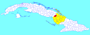
Céspedes municipality (red) within
Camagüey Province (yellow) and Cuba |
||
| Country | Cuba | |
| Province | Camagüey | |
| Named for | Carlos Cespedes | |
| Area | ||
| • Total | 653 km2 (252 sq mi) | |
| Elevation | 75 m (246 ft) | |
| Population
(2022)
|
||
| • Total | 22,842 | |
| • Density | 34.980/km2 (90.60/sq mi) | |
| Time zone | UTC-5 (EST) | |
| Area code(s) | +53-322 | |
| Climate | Aw | |
| Website | http://www.cespedes.gob.cu/ | |
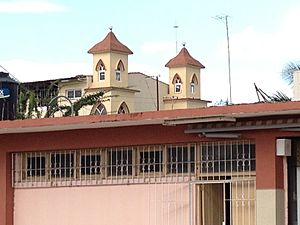
Carlos Manuel de Céspedes, often called Céspedes for short, is a lively town and a municipality in the Camagüey Province of Cuba. It was named after a very important person in Cuban history, Carlos Manuel de Céspedes (1819-1874), who was a leader in the fight for Cuba's independence.
Contents
Where is Céspedes Located?
Céspedes is found in the western part of the Camagüey Province. It's located right along the main highway that crosses Cuba, called the Carretera Central. This makes it easy to travel to and from the town.
Neighboring Areas
The municipality of Céspedes shares its borders with several other places. To its north is Florida, and to the east is Esmeralda. To the west, it borders two municipalities from a different province, Ciego de Ávila Province: Primero de Enero and Baraguá. Within the municipality of Céspedes, you can also find smaller communities like the village of Magarabomba.
How Many People Live Here?
In 2022, the municipality of Carlos M. de Cespedes had a population of 22,842 people. The total area of the municipality is about 653 square kilometers (which is about 252 square miles). This means that on average, there are about 35 people living in each square kilometer.
Getting Around Céspedes
Céspedes is an important spot for transportation in Cuba. The main highway, the Carretera Central, runs right through it, connecting it to other major cities.
Rail and Future Roads
The town also has a railway station. This station is part of the main train line that connects Havana, the capital city, all the way to Santiago de Cuba in the east. There are also plans for a new big highway, the A1 motorway, to be built across the entire island. This new motorway is expected to pass through Céspedes, which will make travel even easier in the future.
See also
 In Spanish: Carlos Manuel de Céspedes (Cuba) para niños
 | Aaron Henry |
 | T. R. M. Howard |
 | Jesse Jackson |


