Esmeralda, Cuba facts for kids
Quick facts for kids
Esmeralda
|
||
|---|---|---|
|
||

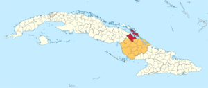
Esmeralda municipality (red) within
Camagüey Province (orange) and Cuba |
||
| Country | Cuba | |
| Province | Camagüey | |
| Established | 1928 | |
| Area | ||
| • Total | 1,480 km2 (570 sq mi) | |
| Elevation | 35 m (115 ft) | |
| Population
(2022)
|
||
| • Total | 29,203 | |
| • Density | 19.73/km2 (51.11/sq mi) | |
| Time zone | UTC-5 (EST) | |
| Area code(s) | +53-322 | |
| Climate | Aw | |
| Website | https://esmeralda.gob.cu/ | |
Esmeralda is a town and a local government area, called a municipality, in Cuba. It is located in the Camagüey Province. The town was officially established in 1928.
Geography of Esmeralda
The Esmeralda municipality is split into smaller areas. These areas are called barrios. The main barrios are Brasil (also known as Jaronú), Caonao, Guanaja, Quemado, and Tabor.
North of Esmeralda, you can find Cayo Romano. This is a small island, or cay, that is part of the Jardines del Rey group of islands. It is across a body of water called the Bay of la Jiguey.
People and Population
In 2022, about 29,203 people lived in the Esmeralda municipality. The total area of Esmeralda is about 1,480 square kilometers (571 square miles). This means that for every square kilometer, there are about 20 people living there. This is known as the population density.
What Esmeralda Produces
The main way people make a living in Esmeralda is through farming. The economy relies on growing several important crops. These crops include sugarcane, which is used to make sugar. Farmers also grow coconuts, pineapples, and oranges. Another important crop grown here is tobacco.
See also
 In Spanish: Esmeralda (Cuba) para niños
 | Delilah Pierce |
 | Gordon Parks |
 | Augusta Savage |
 | Charles Ethan Porter |


