
Carn Brea, Redruth facts for kids

Carn Brea (which means Karnbre in Cornish) is a famous hilltop spot and a local area in Cornwall, England. About 8,000 people live in the Carn Brea area. The hill is located about one mile (1.6 km) southwest of Redruth. Many small villages and towns are part of the Carn Brea parish, including Bosleake, Brea, Carnkie, Four Lanes, Pool, and Tuckingmill.
Contents
Ancient History of Carn Brea
Carn Brea has a very long history, going back thousands of years! People lived here a long, long time ago, even before the pyramids were built.
Stone Age Village
Around 3700 to 3400 BC, during the Neolithic period (also known as the New Stone Age), a village stood on Carn Brea. It was built inside a special stone wall area called a tor enclosure. Archaeologists, who are like history detectives, dug up the site in the 1970s.
The village had two main parts. An inner area of about two acres was surrounded by a larger area of eleven acres. Stone walls, earth banks, and ditches protected the village. Inside, archaeologists found traces of fourteen platforms where Stone Age longhouses would have stood. They also found old pottery and tools made from flint.
Experts believe about 100 to 150 people lived here. These early settlers cleared the land for farming by burning plants and moving stones. They were also skilled at making stone axes from rocks found nearby. They even traded these axes and pottery with people from far away, showing they had a busy economy.
Many flint arrowheads were found scattered around the site. Some were near what might have been the village entrance. This suggests there might have been a big fight or attack on the village long ago. Evidence shows that the wooden buildings were burned down, and the protective earthworks might have been damaged by invaders.
Iron Age Discoveries
Later, during the Iron Age, people came back to live on Carn Brea. They started mining minerals from the hillside. Archaeologists found parts of old huts and pottery from this time.
In the 1700s, a collection of gold coins from ancient Gaul (now France) and Kent (in England) was found here. This shows that Carn Brea was connected to places far away even then. Around AD 700, an old map called the Ravenna Cosmography might have mentioned Carn Brea as a "fort" or "walled settlement."
Famous Landmarks on the Hill
Carn Brea is home to several interesting landmarks that you can still see today.
-
Basset Monument
-
Cup and Saucer Rock


Carn Brea Castle
Carn Brea Castle sits near the top of the hill. It was built in the 1700s by the Basset family. They used it as a hunting lodge, a place to stay when they went hunting. The castle looks quite unusual because it's built right on top of huge rocks, making it seem like it's melting into the land.
In the 1980s, the castle was turned into a restaurant that serves Middle Eastern food. A fun fact: the famous flying Ford Anglia car from the Harry Potter films was found at the castle in 2006 after it was reported stolen! 50°13′20.85″N 5°14′41.40″W / 50.2224583°N 5.2448333°W
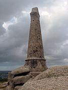
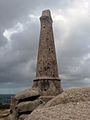
The Basset Monument
At the very highest point of Carn Brea, you'll see a tall, 90-foot (27m) monument shaped like a Celtic cross. This monument was built in 1836 to remember Francis Basset, 1st Baron de Dunstanville and Basset. He was an important mine owner in the area. He was honored for helping to protect Plymouth from French and Spanish ships in 1779 and for helping to calm a protest by miners in 1785. He also spoke out against slavery. The monument has a message carved into it: "The County of Cornwall to the memory of Francis Lord de Dunstanville and Basset A.D. 1836." 50°13′16″N 5°14′56″W / 50.22111°N 5.24889°W
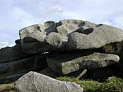
Cup and Saucer Rock
Right next to the Basset Monument is a large, flat rock called the "Cup and Saucer Rock." It has several deep, bowl-like hollows in it. Some people used to call it "The Sacrificing Rock," but we don't know for sure if it was ever used for sacrifices. 50°13′16″N 5°14′54″W / 50.22111°N 5.24833°W
The Smugglers' Cave

Between the monument and the castle, you can find the remains of what's called the "Smugglers' Cave." The entrance was blocked with rocks in the 1980s to keep people safe. There's a rumor that the tunnel goes all the way from the top of the hill down to Redruth town! However, it's probably just an old mine tunnel. Some people might confuse it with another tunnel that supposedly went from the castle to St Euny's church, which was also blocked for safety reasons around 1970. 50°13′19″N 5°14′50″W / 50.22194°N 5.24722°W
Saint Euny's Well
At the bottom of Carn Brea, near St Euny's Church, is Saint Euny's Well. A sign there says, "St Euny Well. Holy well of St Euny visited by the Celtic Missionary 500AD." This well is thought to be a very old and special place.
Fun Events at Carn Brea
Carn Brea is a place where many local traditions and events happen throughout the year.
Every Easter, Redruth Baptist Church puts up a lit cross on the rocks behind the castle. On Easter Sunday, a Christian sunrise service is held there, which is a very special way to start the day.
On Midsummer Eve (June 23rd), there's a traditional bonfire ceremony. This old custom started as a way to celebrate and bring good luck. Prayers are read in the Cornish language, and then the bonfire is lit. This fire signals other bonfires to be lit across Cornwall, from Sennen to the River Tamar. Once only the glowing embers are left, young people sometimes leap over them. This is believed to chase away bad luck and bring good fortune.
On Boxing Day, the Four Burrow Hunt starts at the top of Carn Brea. While fox hunting rules have changed, this event continues as a traditional gathering.
Images for kids
-
Basset Monument
