Caroline Street (Key West) facts for kids

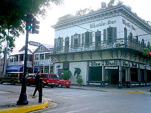
The Bull and Whistle Bar at the corner of Caroline Street (left) and Duval Street (right)
|
|
| Maintained by | City of Key West |
|---|---|
| Length | 0.5 mi (0.8 km) |
| West end | Whitehead Street in Key West |
| East end | Grinnell Street in Key West |
Caroline Street is a very old and important road in Key West, Florida. It stretches about half a mile (0.8 km) from Whitehead Street in the southwest to Grinnell Street in the northeast. This street is one of the oldest on the island.
You'll find many historic houses, inns, and businesses along Caroline Street. Many of the old homes are hidden behind lots of plants and trees. The street starts mostly with houses, then becomes busier with shops and restaurants. Caroline Street is part of the historic "Old Town" area of Key West. It was first planned out in 1829 when the island was mapped. The street hasn't changed much since then, except for its very ends. It was named after Caroline Whitehead, whose brother, John, first became interested in Key West after a shipwreck in 1819.
Contents
Exploring Caroline Street: What You'll See
Caroline Street begins at Whitehead Street. Here, you'll see the gates to the Truman Annex, which used to be a naval base. This part of Caroline Street is quiet and shady. It's just a short walk from the end of U.S. Route 1, a famous highway.
Shops and Historic Homes
As you move northeast, the street opens up to shops and businesses. You'll reach Duval Street, a very busy area. At this corner, you'll find places like The Bull and Whistle Bar. After Duval Street, Caroline Street quickly becomes mostly residential again.
The houses along this part of Caroline Street are very special. They are built in a "conch style" from the late 1800s. This style mixes ideas from Victorian and Colonial designs. Even though they were built quickly, they used boat-building methods. This made them strong against bad weather. Many of these grand homes are hidden by beautiful gardens.
From Quiet Streets to Waterfront Views
Further along, Caroline Street crosses Simonton Street, which is less busy than Duval. After another block of shaded homes, you'll reach Elizabeth Street. This is a turning point for Caroline Street. It starts to have more small shops as it meets Peacon Lane.
As Caroline Street continues, it crosses William Street. From here, you can catch glimpses of the Gulf of Mexico and boats in the harbor. It's a great spot to see the "practical" side of Key West's connection to the sea.
Between William and Margaret Street, you'll find many restaurants. You can also see the Key West Bight, which is a harbor area. You can get to the Bight by turning left on Margaret Street. Look for a large mural by artist Robert Wyland at the Key West Waterfront Brewery entrance. The last part of Caroline Street is quieter, with a few more houses and businesses. It ends at Grinnell Street, after traveling about half a mile.
Caroline Street's Past: A Look Back
Caroline Street is in the "Old Town Key West" historic district. This area has many old houses, some of which belonged to famous people. For example, the Dr. Joseph Y. Porter House at 429 Caroline Street was home to Florida's first public health inspector. This house was added to the National Register of Historic Places in 1973. Many old houses have been turned into inns, like the Curry Mansion Inn. It was built in 1855 for the important Curry family.
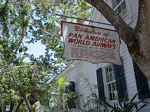
At the very start of Caroline Street, near the Truman Annex gates, is the Airways Building. This building was the first office for Pan American World Airways when it started in 1927.
How Caroline Street Got Its Name
Caroline Street, along with Margaret, William, Thomas, and Emma streets, were named after the brothers and sisters of John Whitehead. John Whitehead was shipwrecked on Key West in 1819. He saw how important the island's location was. His brother, William, mapped out the city of Key West in 1829.
The original map from 1829 shows the "town plot" area. This was the only part of the island with a grid of streets. Caroline Street was one of these streets, running from southwest to northeast. This means Caroline Street was cleared by 1829, making it one of the oldest streets in Key West. We don't know exactly when it got its name.
Changes Over Time
Today, Caroline Street doesn't reach the water at either end. But the 1829 map shows it used to go all the way to the Gulf of Mexico at both ends. Later maps from the early 1900s also show it touching the water. Over time, the street was cut off from the water. The Truman Annex was built at one end, and a power plant was built on new land at the other.
Since 1996, the upper part of Caroline Street and the Key West Bight area have been getting improvements. The City of Key West has led these efforts. This area used to be mainly for commercial fishing. The improvements have included better lighting, new signs, and more sidewalks. They also made it easier for bikes and people to get around.


