Cartago, Valle del Cauca facts for kids
Quick facts for kids
Cartago
|
|||
|---|---|---|---|
|
Municipality and city
|
|||
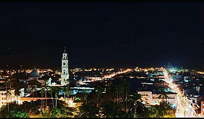
Aerial view of Cartago with the Cathedral of Cartago to the left side.
|
|||
|
|||
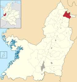
Location of the municipality and town of Cartago, Colombia in the Valle del Cauca Department of Colombia.
|
|||
| Country | |||
| Department | Valle del Cauca Department | ||
| Founded | 1540 | ||
| Area | |||
| • Total | 279 km2 (108 sq mi) | ||
| Elevation | 917 m (3,009 ft) | ||
| Population
(2023 est.)
|
|||
| • Total | 142,902 | ||
| • Density | 512.2/km2 (1,326.6/sq mi) | ||
| Demonym(s) | Cartagüeño | ||
| Time zone | UTC-5 (Colombia Standard Time) | ||
| Area code(s) | 57 + 2 | ||
| Climate | Af | ||
Cartago (Spanish pronunciation: [kaɾˈtaɣo]) is a city in southwestern Colombia. It is located in the northern part of the Valle del Cauca region. The city is about 187 miles (300 km) west of Bogotá, the capital of Colombia.
Cartago is very close to the city of Pereira in the Risaralda region, only about a 20-minute drive away. It is the sixth largest city in Valle del Cauca. Other big cities in the region include Cali, Palmira, Buenaventura, Tuluá, and Jamundí. In 2018, about 142,902 people lived in Cartago.
Contents
Discover Cartago's Warm Climate
Cartago has warm weather all year round. The average temperature is about 24°C (75°F). Temperatures usually stay between 20°C (67°F) and 29°C (84°F). It rarely gets colder than 19°C (66°F) or hotter than 31°C (88°F).
The city is known for its many farmhouses and fun places to visit. People from nearby Pereira often come to Cartago to relax and enjoy the warm weather.
Learning in Cartago
Cartago offers good opportunities for education. The University of Valle has a campus right here in the city. The main campus of this university is in Cali, the capital of the department.
Besides the university, there are also private schools. These include the Instituto Técnico Colombiano, INTEC Cartago, and Sena Institute.
Exploring Cartago's Culture
Cartago is a place where you can find beautiful handmade products. These Artesanías are sold in many shops along the roads.
A painting from 1856 by Manuel María Paz shows what Cartago looked like a long time ago. It shows a couple in a roadside shop. It also shows that Afro Colombians lived in the town back then.
Fun Festivals in Cartago
Cartago hosts several exciting festivals throughout the year:
- Pedro Morales Pino Festival of Andean Colombian Music (Spanish: Festival de Música Andina Colombiana Pedro Morales Pino): This festival happens from February 4th to March 4th. It started in 2013 to celebrate the 150th birthday of Pedro Morales Pino. He was a very talented local musician who played the Bandola. The local music school named after him organizes this event.
- Feria de diseño independiente LAS PULGAS: This is a design fair organized by a group called 3 VECES. It takes place twice a year, in March and December.
- Encuentro Nacional de las Familias que Cantan: This event, which means "National Gathering of Singing Families," is organized by the Pedro Morales Pino Conservatory in July.
Getting Around Cartago
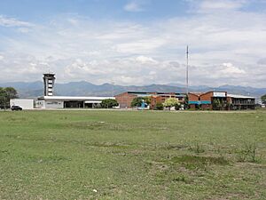
Cartago has its own airport called Santa Ana Airport. If you need to travel further, the Matecaña International Airport is nearby and serves the city of Pereira.
Within Cartago, it's easy to get around. The city has many taxis available. You can also use minibuses, which are called busetas, to travel around town.
Famous People from Cartago
Some well-known people come from Cartago:
- Billy Pontoni – a famous singer.
- The Franco Family – known for being doctors and architects.
Climate
| Climate data for La Virginia , elevation 970 m (3,180 ft), (1981–2010) | |||||||||||||
|---|---|---|---|---|---|---|---|---|---|---|---|---|---|
| Month | Jan | Feb | Mar | Apr | May | Jun | Jul | Aug | Sep | Oct | Nov | Dec | Year |
| Mean daily maximum °C (°F) | 30.6 (87.1) |
31.0 (87.8) |
30.6 (87.1) |
29.9 (85.8) |
29.6 (85.3) |
29.7 (85.5) |
30.3 (86.5) |
30.7 (87.3) |
30.5 (86.9) |
29.5 (85.1) |
29.2 (84.6) |
29.6 (85.3) |
30.1 (86.2) |
| Daily mean °C (°F) | 24.1 (75.4) |
24.3 (75.7) |
24.2 (75.6) |
23.9 (75.0) |
23.8 (74.8) |
23.9 (75.0) |
24.1 (75.4) |
24.4 (75.9) |
23.9 (75.0) |
23.4 (74.1) |
23.4 (74.1) |
23.7 (74.7) |
23.9 (75.0) |
| Mean daily minimum °C (°F) | 19.1 (66.4) |
19.3 (66.7) |
19.3 (66.7) |
19.5 (67.1) |
19.5 (67.1) |
19.1 (66.4) |
18.8 (65.8) |
18.7 (65.7) |
18.8 (65.8) |
18.9 (66.0) |
19.1 (66.4) |
19.1 (66.4) |
19.1 (66.4) |
| Average precipitation mm (inches) | 109.3 (4.30) |
105.7 (4.16) |
176.0 (6.93) |
210.5 (8.29) |
247.2 (9.73) |
148.4 (5.84) |
131.0 (5.16) |
122.2 (4.81) |
161.3 (6.35) |
184.6 (7.27) |
216.7 (8.53) |
139.4 (5.49) |
1,952.3 (76.86) |
| Average precipitation days | 13 | 13 | 17 | 20 | 20 | 17 | 14 | 13 | 16 | 20 | 20 | 16 | 197 |
| Average relative humidity (%) | 74 | 73 | 75 | 78 | 80 | 78 | 74 | 72 | 74 | 77 | 78 | 77 | 76 |
| Mean monthly sunshine hours | 198.4 | 166.6 | 170.5 | 141.0 | 148.8 | 150.0 | 182.9 | 186.0 | 162.0 | 151.9 | 156.0 | 179.8 | 1,993.9 |
| Mean daily sunshine hours | 6.4 | 5.9 | 5.5 | 4.7 | 4.8 | 5.0 | 5.9 | 6.0 | 5.4 | 4.9 | 5.2 | 5.8 | 5.5 |
| Source: Instituto de Hidrologia Meteorologia y Estudios Ambientales | |||||||||||||
See also
 In Spanish: Cartago (Valle del Cauca) para niños


