Castleton, Indianapolis facts for kids
Quick facts for kids
Castleton
|
|
|---|---|

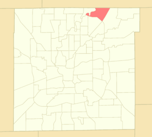
Location of Castleton within Indianapolis–Marion County, Indiana
|
|
| Country | United States |
| State | Indiana |
| County | Marion |
| Townships | Lawrence, Washington |
| City | Indianapolis |
| Population
(2020)
|
|
| • Total | 11,198 |
| Time zone | UTC−5 (EST) |
| • Summer (DST) | UTC−4 (EDT) |
| ZIP codes |
46250, 46256
|
| Area code(s) | 317 / 463 |
Castleton is a neighborhood on the northeast side of Indianapolis, Indiana, in the United States. It is located in parts of Lawrence and Washington townships.
Castleton used to be its own town for over 100 years. But in 1970, it became part of Indianapolis when the city and county governments joined together. This joining was called Unigov. Castleton officially stopped being a separate town in 1992. Today, Castleton is mostly a busy area with lots of shops and offices.
Contents
Where is Castleton Located?
Castleton is about 12 miles (19 km) northeast of downtown Indianapolis. The original town was first planned near 82nd Street and an old railroad line called the Nickel Plate Road.
Understanding Castleton's Boundaries
The neighborhood area of Castleton today is much bigger than the old town. This larger area is used to understand the population and other facts about the people living there. Castleton is surrounded by:
- 96th Street to the north
- The White River to the west
- Interstate 69 to the east
- 82nd Street and Interstate 465 to the south
The Story of Castleton
Castleton was started in 1852 by a person named Thomas Gentry. It grew into a small town that helped local farmers and people traveling on the Nickel Plate Road railroad.
Early Growth and Development
Over the next few decades, Castleton slowly grew. It got a church, a school, buildings to store grain, and a train station. The town held its first official meeting in 1906. By 1950, about 268 people lived there.
Changes and Modern Growth
In 1965, local officials decided to change how the land in Castleton could be used. They planned for more shops and light industries. This was because new highways were going to be built nearby.
The building of Interstates 69 and 465 meant some buildings in Castleton had to be taken down. This included a church, a special meeting hall called a Masonic temple, and a school.
On January 1, 1970, Castleton officially became part of the larger Indianapolis city-county government. This big change was known as Unigov.
The Impact of Castleton Square
In 1972, a huge shopping mall called Castleton Square opened. It was the biggest enclosed mall in Indiana at the time. After the mall opened, many new homes, apartments, shopping centers, and office buildings were built in the 1980s and 1990s. This made the area grow very quickly.
Castleton Today
On November 18, 1991, the town board decided that Castleton would no longer be a separate town. Indianapolis Mayor Stephen Goldsmith approved this decision, and it became official on January 19, 1992.
Today, Castleton is still one of the busiest areas in Indianapolis for shops and offices. It has a lot of retail space (for stores) and commercial office space (for businesses).
 | Delilah Pierce |
 | Gordon Parks |
 | Augusta Savage |
 | Charles Ethan Porter |

