
Catacamas facts for kids
Quick facts for kids
Catacamas
Cata
|
|
|---|---|
|
Municipality
|
|

A street scene in central Catacamas -the 'Mirador de la Cruz' is visible in the background
|
|

Catacamas
Location in Honduras
|
|
| Country | |
| Department | Olancho |
| Founded | 24 January 1898 |
| Government | |
| • Type | Municipality |
| Area | |
| • Municipality | 7,264 km2 (2,805 sq mi) |
| Elevation | 450 m (1,480 ft) |
| Population
(2023 projection)
|
|
| • Municipality | 140,548 |
| • Density | 19.3486/km2 (50.113/sq mi) |
| • Urban | 63,310 |
| Time zone | UTC-UTC/GMT -6 hours |
| Climate | Aw/Tropical savanna |
Catacamas is a city and a municipality in the Olancho Department of Honduras. About 63,310 people live in the city (as of 2023).
It is the largest municipality in Central America by land area.
Contents
Discover Catacamas: The Florida City
Catacamas is often called the Florida City. This name was given to it by the famous poet Froylán Turcios. The city sits on a large, flat area. The Rio Guayape river flows through this area. This makes the land very green and fertile.
Catacamas is about 210 kilometers (130 miles) northeast of Tegucigalpa. Tegucigalpa is the capital city of Honduras. You can easily reach Catacamas by a paved road. The people of Catacamas are known for being friendly and strong. They also have a spirit of progress.
Nature and Wildlife Around Catacamas
The city is located in a valley. It is about 450 meters (1,476 feet) above sea level. Near the city is the North White Stone Mountain. This mountain is part of the Agalta Mountains National Park. This park is home to many different plants. You can find pine trees, broadleaf plants, and about 80 types of orchids.
The area also has many animals. You might see wild cats and the beautiful quetzal bird. To the north and west are mountains like "Cerro de la Cruz". From these hills, you can see amazing views of the city. This includes the sports center and cultural park "Ramón Díaz López".
Famous Caves and Rivers
About five kilometers (3 miles) east of Catacamas are the famous Talgua caves. These caves were found in 1935. A special discovery in the caves was the "Glowing Skulls." These are skeletons of Pech Indian people. They are about three thousand years old.
About six kilometers (3.7 miles) south of Catacamas is the Guayape River. This river is known for gold. The Guayape River joins with the Guayambre River to form the Patuca River. The Patuca is the second longest river in Honduras. Between these two rivers is the Cordillera Entre Ríos mountain range. This area is also part of the Catacamas municipality.
Size and Location
Catacamas and the Olancho Department are both very large. Catacamas is the biggest municipality in Honduras. Its area is about 7,228.5 square kilometers (2,791 square miles).
The city of Catacamas is located at 14°54'04" north latitude and 85°55'31" west longitude. It borders Gualaco to the north. To the south are San Esteban and Dulce Nombre de Culmí. To the east are Dulce Nombre de Culmí and Jinotega, Nicaragua. To the west are Santa María del Real, San Francisco de Becerra, and Juticalpa. The Talgua River flows east of the town. It then joins the Guayape River.
City Life and Landmarks
The Catholic Church "San Francisco de Asis" is a main building in the town. It stands across from the municipal building. The Parque Central is in the center of Catacamas city. It is a popular spot for town life.
Some villages within the Catacamas municipality include El Esquilinchuche. This village is located on the banks of the Guayape river.
People of Catacamas
In 2013, a census counted 117,493 people in the Catacamas municipality. Most of the people (about 94.73%) are Mestizo. This means they have mixed European and Indigenous heritage. About 3.94% are White. About 0.69% are Black or Afro-Honduran. A small number (0.47%) are Indigenous.
Weather in Catacamas
Catacamas has a Tropical wet and dry climate. This means it has a wet season and a dry season. It is generally warm all year round.
| Climate data for Catacamas, Honduras | |||||||||||||
|---|---|---|---|---|---|---|---|---|---|---|---|---|---|
| Month | Jan | Feb | Mar | Apr | May | Jun | Jul | Aug | Sep | Oct | Nov | Dec | Year |
| Record high °C (°F) | 33.5 (92.3) |
37.5 (99.5) |
39.9 (103.8) |
38.5 (101.3) |
38.4 (101.1) |
37.0 (98.6) |
33.8 (92.8) |
34.9 (94.8) |
32.5 (90.5) |
32.4 (90.3) |
33.0 (91.4) |
33.1 (91.6) |
39.9 (103.8) |
| Mean daily maximum °C (°F) | 28.5 (83.3) |
29.6 (85.3) |
31.3 (88.3) |
32.3 (90.1) |
32.4 (90.3) |
30.5 (86.9) |
29.7 (85.5) |
30.3 (86.5) |
30.5 (86.9) |
30.4 (86.7) |
29.2 (84.6) |
28.4 (83.1) |
30.3 (86.5) |
| Daily mean °C (°F) | 22.9 (73.2) |
23.9 (75.0) |
25.6 (78.1) |
26.8 (80.2) |
27.0 (80.6) |
25.6 (78.1) |
24.9 (76.8) |
25.1 (77.2) |
25.4 (77.7) |
24.8 (76.6) |
23.8 (74.8) |
23.1 (73.6) |
24.9 (76.8) |
| Mean daily minimum °C (°F) | 17.9 (64.2) |
18.4 (65.1) |
19.6 (67.3) |
20.8 (69.4) |
21.7 (71.1) |
21.4 (70.5) |
20.6 (69.1) |
20.6 (69.1) |
20.6 (69.1) |
20.1 (68.2) |
19.1 (66.4) |
18.3 (64.9) |
19.9 (67.8) |
| Record low °C (°F) | 11.9 (53.4) |
11.9 (53.4) |
13.4 (56.1) |
15.7 (60.3) |
18.9 (66.0) |
19.5 (67.1) |
18.4 (65.1) |
18.6 (65.5) |
18.8 (65.8) |
17.5 (63.5) |
12.5 (54.5) |
12.1 (53.8) |
11.9 (53.4) |
| Average precipitation mm (inches) | 42.4 (1.67) |
26.3 (1.04) |
20.5 (0.81) |
37.5 (1.48) |
137.2 (5.40) |
245.4 (9.66) |
234.0 (9.21) |
184.5 (7.26) |
198.9 (7.83) |
153.8 (6.06) |
76.1 (3.00) |
52.6 (2.07) |
1,409.2 (55.48) |
| Average precipitation days (≥ 1.0 mm) | 6 | 5 | 3 | 3 | 9 | 17 | 19 | 25 | 16 | 13 | 9 | 8 | 133 |
| Source: NOAA | |||||||||||||
City Improvements and Travel
Catacamas has been improving its streets. Many city streets are now paved. There are plans to pave even more new streets and main roads.
Rural roads have also been paved. This makes it easier to move products around. For example, the trip between Dulce Nombre de Culmí and Catacamas now takes only 45 minutes by car.
Roads and Airport
The main highway to the capital city, Tegucigalpa, is paved. This road is about 210 kilometers (130 miles) long. It takes about 4 hours to drive. This highway also connects to San Pedro Sula and the north coast.
The road to Dulce Nombre de Culmí is also paved. In June 2011, a new airport was planned to open in Aguacate. This airport is a few kilometers towards Culmí.
Services for the Community
Catacamas has different services for its people. There are plans for better waste management. A new water treatment plant is also being planned.
For communication, there are several options. Hondutel provides landline phone service. There are also four cell phone companies. For TV, there are two cable providers and five local TV stations. You can listen to 15 local radio stations and one national station.
A new electric power station is being built. This will help provide more reliable electricity.
Health and Education
A private Catholic hospital is being built in Catacamas. People are also asking for a public hospital.
Catacamas is home to the Universidad Nacional de Agricultura (National Agriculture University). This university focuses on farming and related studies.
Sports in Catacamas
The local football (soccer) team is called Atlético Olanchano. They play their games at the Estadio Rubén Guifarro. The team has played in Honduras' top football league. Currently, they play in the country's second division.
Economy and Jobs
Catacamas is rich in dairy products, meat, and basic grains like corn and beans. Many people work in farming and raising animals. The city also has industries that make milk products, sand blocks, and baked goods.
The economy is growing in a few areas:
- Construction: Many new houses and developments are being built. People who used to live in Catacamas but now live abroad often buy these homes.
- Tourism: Catacamas is working to attract more visitors. They are creating eco-tourism routes. They are also training tour guides, restaurant workers, and hotel staff.
- Sustainable Coffee: Some coffee farms in the region have a special certification. It's called the Rainforest Alliance Certificate. This means they grow coffee in a way that protects the environment. This also helps them get better prices for their coffee.
Talgua Caves: The Glowing Skulls
The Talgua caves are one of the most famous places to visit. They are also known as "The Cave of the Glowing Skulls." These caves are a few miles northeast of Catacamas. Long ago, native people used the caves as a burial site. Over time, minerals from the cave ceiling covered the bones. This made them look like they glowed.
Tests show that the burials happened around 900 B.C. This was long before the Maya civilization grew. The main burial chamber was found in 1994. It was discovered by Timothy Berg, a Peace Corps Volunteer, and two local men, Desiderio Reyes and Jorge Yánez. Scientists are still studying the area today.
Gallery
-
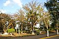
Parque Central in Catacamas - for size reference, the trunk of the central tree is 14 feet across.
-
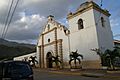
The Church in the center of Catacamas, 'San Francisco de Asis'.
-
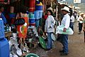
A picture of one of the many open-air markets in central Catacamas.


See also
 In Spanish: Catacamas para niños
