
Catacol Bay facts for kids
Quick facts for kids Catacol Bay |
|
|---|---|

Shoreline of Catacol bay looking north.
|
|

Catacol Bay
Location in North Ayrshire
|
|
| Location | Isle of Arran, North Ayrshire Scotland |
| Coordinates | 55°41′26.4012″N 5°19′57.0864″W / 55.690667000°N 5.332524000°W |
| River sources | Glen Catacol |
| Ocean/sea sources | Kilbrannan Sound |
| Basin countries | Scotland |
| Max. length | 1.8 km (1.1 mi) |
| Max. width | 0.45 km (0.28 mi) |
| Settlements | Catacol |
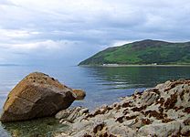
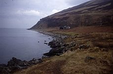
Catacol Bay (which is Catagal bhàigh in Scottish Gaelic) is a lovely, small bay on the northwest side of the Isle of Arran in Scotland. It's part of the Firth of Clyde, which is a large sea area. The bay faces west and has a rocky coastline. It's a great spot to enjoy the views and learn about the local history.
Contents
Exploring the Area Around Catacol Bay
Catacol Bay looks out onto the Kilbrannan Sound. This is a narrow stretch of water that separates the Isle of Arran from the Kintyre Peninsula. From the bay, you can see amazing views of the peninsula across the water. The Kilbrannan Sound is like the western arm of the bigger Firth of Clyde.
Hills and Valleys
South of the bay, you'll see a hill called Meall nan Damh. It stands tall at 570 metres. This hill is part of the Pirnmill Hills and sits above a valley called Glen Catacol. One of the most beautiful lochs (lakes) on Arran, Loch Corrie, is nestled between Meall nan Damh and another hill, Meal Biorach, which is 551 metres high. A bit further south, there's a smaller hill named Meall Mòr, standing at 496 metres.
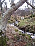
Behind the bay is Glen Catacol, a valley with very steep sides. It's made of strong rocks like granite and basalt. The Glen Catacol river flows down this valley. A smaller stream called Gleann Diohan joins it near the bottom of a hill called Meall nan Leac Sleamhuinn, which is 272 metres high.
Nearby Places
Just about 1 mile north of Catacol Bay, you'll find a sea loch called Loch Ranza. If you head south from Catacol Bay, the next bay you'll reach is Machrie Bay, which is about 11.5 miles away.
The Village of Catacol
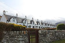
The small village of Catacol has a cool Norse name, which means "The gully of the cat." It's famous for a row of low, white houses called the 'Twelve Apostles'. These cottages were built a long time ago for people who had to move from their farms. This happened when parts of the island were set aside for deer.
The Twelve Apostles Cottages
The idea was that these former farmers would become fishermen. To help with this, each of the twelve cottages had a unique first-floor window shape. This way, a woman could place a candle in her window. Her husband, out fishing in the Firth of Clyde, would know it was her signaling by the shape of the window. However, many of the people who had to move actually left the island in protest.
Other Villages Nearby
Close to Catacol, along the C147 road, you'll find the old Catacol Bay Hotel, which is now closed. About 1 mile northeast of the bay, along the A841 road, is Lochranza. If you travel almost 5 miles southwest of Catacol on the C147 road, you'll reach Pirnmill. This used to be an industrial village but is now a popular spot for tourists.
Special Features
The Fairy Dell
Above Lochranza, there's a magical place called the Fairy Dell. People say that Fairy folk used to dance there. It's a very peaceful and beautiful spot.
Gallery
-
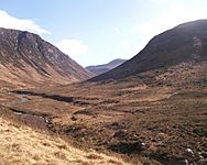
Glen Catacol with Glen Catacol river.
-
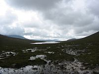
Loch Tanna, seen from Glen Catacol.
-
Catacol Bay on a beautiful day.
-
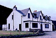
Catacol Bay Hotel
-
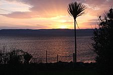
Sunset over Catacol Bay.
-
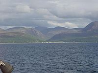
Catacol Bay showing the Glen Catacol, taken from the Lochranza-Claonig Ferry.
-
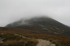
Meall nam Damh
-
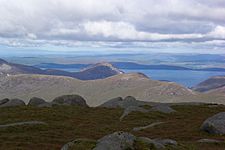
Northern Slopes of Meall Biorach. Looking up from the Coire Fhionn Lochan path.
-
Twelve apostles.
-
Fairy Dell mouth A lonely house sits on the raised beach at the end of Fairy Dell. Behind, the hillside seems to be tumbling into the sea.
-
Winter in the Fairy Dell.


