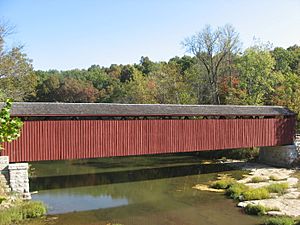
Cataract Falls Covered Bridge facts for kids
Quick facts for kids Cataract Falls Covered Bridge |
|
|---|---|
 |
|
| Coordinates | 39°26′00″N 86°48′47″W / 39.43333°N 86.81306°W |
| Crosses | Mill Creek (formerly known as Eel River) |
| Locale | Owen County, Indiana, United States |
| NBI Number | INNBI 6000029 |
| Characteristics | |
| Design | U.S. National Register of Historic Places |
| Total length | 140.1 ft (42.7 m)(total length) |
| Width | 13.5 m (44 ft) |
| Height | 12.5 ft (3.8 m) |
| History | |
| Constructed by | Smith Bridge Co. |
| NRHP reference No. | 05000339 |
| Added to NRHP | 2005 |
| Lua error in Module:Location_map at line 420: attempt to index field 'wikibase' (a nil value). | |
The Cataract Falls Covered Bridge is a really old and special bridge in Indiana, USA. It's called a "covered bridge" because it has a roof and sides, just like a house! This bridge crosses a stream called Mill Creek. You can find it in the Lieber State Recreation Area in Owen County.
Contents
Discover the Cataract Falls Covered Bridge
This amazing bridge was built way back in 1876. A company called Smith Bridge Co. from Toledo, Ohio constructed it. For many years, it was one of the most famous and photographed covered bridges in the entire United States. It's also special because it's the only covered bridge left in Owen County today.
Why is it Covered?
You might wonder why bridges like this have roofs and walls. The main reason is to protect the wooden parts of the bridge from weather. Rain, snow, and sun can damage wood over time. By covering the bridge, the builders made it last much longer. It's like putting a hat and coat on the bridge!
A Bridge for Pedestrians
For a long time, cars and wagons used to drive across the Cataract Falls Covered Bridge. But in 1988, a new road was built that went around the bridge. This meant cars no longer needed to use it. Now, the bridge is only open for people to walk across. It's a great spot for a stroll and to enjoy the scenery.
A Historic Landmark
Because of its age and importance, the Cataract Falls Covered Bridge was added to the National Register of Historic Places in 2005. This is a special list of places in the U.S. that are important to history and should be preserved. Being on this list helps protect the bridge for future generations to enjoy.
 | Selma Burke |
 | Pauline Powell Burns |
 | Frederick J. Brown |
 | Robert Blackburn |

