
Cauto River facts for kids
Quick facts for kids Cauto River |
|
|---|---|

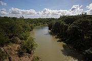
Rio Cauto near Guamo Embarcadero
|
|
 |
|

Location of mouth
|
|
| Country | |
| Physical characteristics | |
| Main source | Sierra Maestra 600 m (1,969 ft) |
| River mouth | Caribbean Sea Gulf of Guacanayabo Sea level 20°32′57″N 77°14′30″W / 20.54917°N 77.24167°W |
| Length | 230 mi (370 km) |
| Basin features | |
| Basin size | 8,928 km2 (3,447 sq mi) |
The Cauto River, also known as Río Cauto, is the longest river in Cuba. It's also the longest river in the entire Caribbean region! This important river is found in the southeast part of Cuba. It's one of only two rivers in Cuba that boats can travel on. The other one is the Sagua la Grande River.
Contents
Journey of the Cauto River
The Cauto River starts its journey in the Sierra Maestra mountains. It flows for about 371 km (231 mi) (230 miles). The river travels towards the west and northwest. Finally, it empties into the Caribbean Sea. This happens north of the city of Manzanillo.
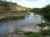
Even though it's very long, only about 110 km (70 mi) (68 miles) of the Cauto River can be used by boats. This means that larger ships cannot travel its entire length.
Where Does the River Flow?
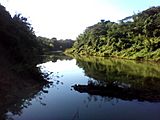
The Cauto River passes through several important provinces in Cuba. These include Santiago de Cuba, Holguin, and Granma. Along its banks, you'll find towns and communities. Some of these are Palma Soriano, Cauto Cristo, and Rio Cauto.
What Grows Along the Cauto?
The land around the Cauto River is very fertile. It helps many farms grow important crops. Farmers here grow rice, sugarcane, and tobacco. The river also supports cattle farming. These crops and animals are very important for Cuba's economy.
How Clean is the River?
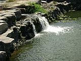
Scientists have studied the Cauto River to check its water quality. A study from 2013 found that the river is generally clean. It was described as "unpolluted to moderately polluted." This means the water is in pretty good shape!
Gallery
- Cauto River
-
-
-
-


See also
 In Spanish: Río Cauto para niños
