Cayo de Agua facts for kids

Cayo de Agua Island
|
|
| Geography | |
|---|---|
| Location | Lesser Antilles Caribbean Sea |
| Coordinates | 11°49′33″N 66°56′34″W / 11.82583°N 66.94278°W |
| Archipelago | Los Roques |
| Area | 0.69 km2 (0.27 sq mi) |
| Length | 8.3 km (5.16 mi) |
| Highest elevation | 6 m (20 ft) |
| Administration | |
| Federal Entity | Federal dependencies of Venezuela |
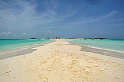
Cayo de Agua (which means Water Key in English) is a beautiful island. It's located in the eastern Caribbean Sea. This island is part of the Los Roques Archipelago in Venezuela. It's also part of a special national park. The island gets its name because it has fresh water wells.
Where is Cayo de Agua?
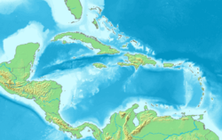
Cayo de Agua is in the northern part of Venezuela. It sits in the far west of the "Los Roques" National Park. To the north, you'll find keys like Puntas de Cocos and Bequevé. To the southeast are the Dos Mosquises keys. Cayo de Agua is quite a distance from the Los Roques airport. The airport is on the island of Gran Roque.
What Can You Do There?
Cayo de Agua is very popular with visitors. People love its beautiful white sands and quiet beaches. You can also see many different kinds of birds around the island. The way the island connects with other small keys creates a natural swimming pool. This makes it a great spot for swimming. There are also fresh water wells on the island. One of the most popular activities here is diving.
Gallery
See Also
 In Spanish: Cayo de Agua para niños
 | Precious Adams |
 | Lauren Anderson |
 | Janet Collins |


