Cedar Creek, Arizona facts for kids
Quick facts for kids
Cedar Creek, Arizona
|
|
|---|---|

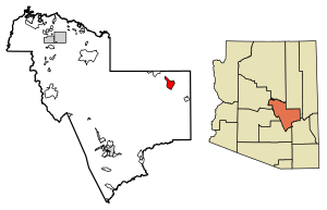
Location of Cedar Creek in Gila County, Arizona.
|
|
| Country | United States |
| State | Arizona |
| County | Gila |
| Area | |
| • Total | 17.04 sq mi (44.12 km2) |
| • Land | 17.04 sq mi (44.12 km2) |
| • Water | 0.00 sq mi (0.00 km2) |
| Elevation | 4,928 ft (1,502 m) |
| Population
(2020)
|
|
| • Total | 372 |
| • Density | 21.84/sq mi (8.43/km2) |
| Time zone | UTC-7 (Mountain (MST)) |
| ZIP code |
85542
|
| Area code(s) | 928 |
| GNIS feature ID | 2619 |
Cedar Creek is a small community in Gila County, Arizona, United States. It is located within the Fort Apache Indian Reservation. This area is known as a census-designated place, which means it's a specific area identified by the U.S. Census Bureau for statistical purposes. Cedar Creek is found along Arizona State Route 73. In 2020, about 372 people lived there.
Where is Cedar Creek?
Cedar Creek is located in Arizona. It covers an area of about 17 square miles (44 square kilometers). All of this area is land, with no large bodies of water. The community sits at an elevation of 4,928 feet (1,502 meters) above sea level.
Who Lives in Cedar Creek?
The number of people living in Cedar Creek changes over time.
| Historical population | |||
|---|---|---|---|
| Census | Pop. | %± | |
| 2020 | 372 | — | |
| U.S. Decennial Census | |||
According to the 2020 census, 372 people called Cedar Creek home.
Getting Around Cedar Creek
The White Mountain Apache Tribe helps people travel around the area. They run a bus service called Fort Apache Connection Transit. This service helps residents get to different places within the community and nearby areas.
See also

- In Spanish: Cedar Creek (Arizona) para niños
 | Misty Copeland |
 | Raven Wilkinson |
 | Debra Austin |
 | Aesha Ash |


