Cedar Gap, Missouri facts for kids
Cedar Gap is a small, unincorporated community located in southwestern Wright County, Missouri. This means it's a place where people live, but it doesn't have its own local government like a city or town. You can find Cedar Gap just south of US Route 60, nestled between the towns of Mansfield to the east and Seymour to the west.
A Glimpse into Cedar Gap's Past
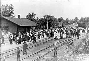
Cedar Gap was first established in 1882. It became a station along the St. Louis-San Francisco Railway line, which connected Springfield to Memphis. The area is about 1,694 feet (516 m) above sea level.
The community got its name from two things: the many cedar trees growing nearby and the "gaps" in the land. These gaps were challenging areas that the railroad had to build bridges over, especially in the rugged terrain of the Lead Hill area. Lead Hill, about 1.8 miles (2.9 km) east, is one of the highest points in Missouri, reaching 1,744 feet (532 m). To help the steam trains, the early railroad also built a dam. This dam created the 40-acre Cedar Gap Lake, located about a mile northwest, to provide water for the trains.
Nature and Waterways
Cedar Gap sits on a special natural boundary called a drainage divide. This means that rainwater falling in Cedar Gap flows in different directions. To the north, water flows into the Gasconade River. To the southeast, it heads towards Bryant Creek, which is a branch of the North Fork River. And to the west, water flows into Finley Creek, a branch of the James River.
The Cedar Gap Conservation Area is a large natural space covering about 431 acres (1.74 km2) of rugged land. It includes the very beginning of Bryant Creek. This conservation area was created in 1999 and is managed by the Missouri Department of Conservation. It helps protect the local wildlife and natural environment.
 | Valerie Thomas |
 | Frederick McKinley Jones |
 | George Edward Alcorn Jr. |
 | Thomas Mensah |


