
Mansfield, Missouri facts for kids
Quick facts for kids
Mansfield, Missouri
|
|
|---|---|

East Parksquare
|
|

Location of Mansfield, Missouri
|
|
| Country | United States |
| State | Missouri |
| County | Wright |
| Area | |
| • Total | 1.90 sq mi (4.91 km2) |
| • Land | 1.88 sq mi (4.87 km2) |
| • Water | 0.02 sq mi (0.04 km2) |
| Elevation | 1,483 ft (452 m) |
| Population
(2020)
|
|
| • Total | 1,193 |
| • Density | 634.57/sq mi (244.96/km2) |
| Time zone | UTC-6 (Central (CST)) |
| • Summer (DST) | UTC-5 (CDT) |
| ZIP code |
65704
|
| Area code(s) | 417 |
| FIPS code | 29-45740 |
| GNIS feature ID | 0721807 |
Mansfield is a city located in Wright County, Missouri, United States. In 2020, about 1,193 people lived there. It's a small community with a rich history and a connection to a famous author.
Contents
History of Mansfield
Mansfield was started in 1882 by a man named F. M. Mansfield. The town was named after him. That same year, a post office opened in Mansfield.
Geography and Location
Mansfield is found in the Ozarks region of Missouri. It sits on the southern edge of an area called the Salem Plateau. Major roads like US Route 60 and Missouri Route 5 pass through the community.
The town is located on a drainage divide. This means that rain falling on one side of Mansfield flows south into rivers that eventually join the White River. Rain on the other side flows north into rivers that lead to the Missouri River.
City Size and Area
According to official records, the city of Mansfield covers a total area of about 1.90 square miles (4.91 square kilometers). Most of this area, about 1.88 square miles (4.87 square kilometers), is land. A small part, about 0.02 square miles (0.04 square kilometers), is water.
Mansfield's Climate
The climate in Mansfield, Missouri, changes throughout the year. Summers are generally warm, and winters are cold. The area gets a good amount of rain, especially in the spring and early summer. Snowfall is usually light.
| Climate data for Mansfield, Missouri (1991–2020 normals, extremes 1962–present) | |||||||||||||
|---|---|---|---|---|---|---|---|---|---|---|---|---|---|
| Month | Jan | Feb | Mar | Apr | May | Jun | Jul | Aug | Sep | Oct | Nov | Dec | Year |
| Record high °F (°C) | 76 (24) |
82 (28) |
85 (29) |
92 (33) |
92 (33) |
104 (40) |
106 (41) |
104 (40) |
103 (39) |
93 (34) |
82 (28) |
73 (23) |
106 (41) |
| Mean daily maximum °F (°C) | 41.6 (5.3) |
46.5 (8.1) |
56.3 (13.5) |
66.0 (18.9) |
74.5 (23.6) |
82.6 (28.1) |
87.7 (30.9) |
87.4 (30.8) |
79.8 (26.6) |
68.6 (20.3) |
55.5 (13.1) |
44.9 (7.2) |
66.0 (18.9) |
| Daily mean °F (°C) | 31.5 (−0.3) |
35.9 (2.2) |
45.1 (7.3) |
54.9 (12.7) |
64.4 (18.0) |
72.9 (22.7) |
77.5 (25.3) |
76.5 (24.7) |
68.4 (20.2) |
57.1 (13.9) |
45.0 (7.2) |
35.6 (2.0) |
55.4 (13.0) |
| Mean daily minimum °F (°C) | 21.4 (−5.9) |
25.3 (−3.7) |
34.0 (1.1) |
43.7 (6.5) |
54.3 (12.4) |
63.2 (17.3) |
67.2 (19.6) |
65.6 (18.7) |
57.0 (13.9) |
45.6 (7.6) |
34.5 (1.4) |
26.2 (−3.2) |
44.8 (7.1) |
| Record low °F (°C) | −25 (−32) |
−16 (−27) |
−1 (−18) |
10 (−12) |
23 (−5) |
32 (0) |
43 (6) |
35 (2) |
20 (−7) |
16 (−9) |
−5 (−21) |
−20 (−29) |
−25 (−32) |
| Average precipitation inches (mm) | 2.73 (69) |
2.76 (70) |
4.25 (108) |
5.39 (137) |
5.52 (140) |
4.16 (106) |
4.40 (112) |
3.35 (85) |
4.07 (103) |
3.62 (92) |
3.97 (101) |
2.87 (73) |
47.09 (1,196) |
| Average snowfall inches (cm) | 2.2 (5.6) |
2.1 (5.3) |
1.9 (4.8) |
0.0 (0.0) |
0.0 (0.0) |
0.0 (0.0) |
0.0 (0.0) |
0.0 (0.0) |
0.0 (0.0) |
0.0 (0.0) |
0.0 (0.0) |
1.5 (3.8) |
7.7 (20) |
| Average precipitation days (≥ 0.01 in) | 6.7 | 7.2 | 9.5 | 9.7 | 11.7 | 9.4 | 8.9 | 7.4 | 7.0 | 8.6 | 8.3 | 7.4 | 101.8 |
| Average snowy days (≥ 0.1 in) | 1.6 | 1.4 | 0.6 | 0.0 | 0.0 | 0.0 | 0.0 | 0.0 | 0.0 | 0.0 | 0.0 | 0.8 | 4.4 |
| Source: NOAA | |||||||||||||
Population Changes
The number of people living in Mansfield has changed over the years. A census is a count of the population. The U.S. government does a census every ten years.
| Historical population | |||
|---|---|---|---|
| Census | Pop. | %± | |
| 1900 | 494 | — | |
| 1910 | 477 | −3.4% | |
| 1920 | 757 | 58.7% | |
| 1930 | 861 | 13.7% | |
| 1940 | 922 | 7.1% | |
| 1950 | 963 | 4.4% | |
| 1960 | 949 | −1.5% | |
| 1970 | 1,056 | 11.3% | |
| 1980 | 1,423 | 34.8% | |
| 1990 | 1,429 | 0.4% | |
| 2000 | 1,349 | −5.6% | |
| 2010 | 1,296 | −3.9% | |
| 2020 | 1,193 | −7.9% | |
| U.S. Decennial Census | |||
In 2010, there were 1,296 people living in Mansfield. These people lived in 568 households. About 30% of these households had children under 18. The average age of people in the city was about 38 years old.
Education in Mansfield
The public schools in Mansfield are managed by the Mansfield R-IV School District. For reading and learning, Mansfield has a public library called the Laura Ingalls Wilder Public Library.
Famous People from Mansfield
Mansfield is known for its connection to a very famous author.
Laura Ingalls Wilder
In 1894, Laura Ingalls Wilder, who wrote the "Little House on the Prairie" books, moved to Mansfield. She came with her husband, Almanzo, and their daughter, Rose. They lived in the area for 60 years. They built a successful farm called Rocky Ridge Farm.
Today, their unique 10-room farmhouse is a National Historic Landmark. It is now the Laura Ingalls Wilder Home and Museum. Thousands of visitors come to Mansfield each year to see it. The Wilders also lived for a time in the Rock House, which their daughter Rose built for them.
- Buildings of the museum
-
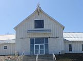
Laura Ingalls Wilder Museum in Mansfield
-
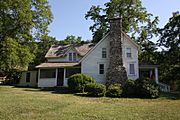
Rocky Ridge Farm
-
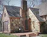
Rock House at Wilder complex


.JPG)
Other Notable People
- As a young man, future actor Ken Osmond lived near the Wilders. He was known for his role in the TV show Leave It to Beaver.
- Evangelical theologian Timothy Paul Jones was born in Mansfield, Missouri.
See also
 In Spanish: Mansfield (Misuri) para niños
