Cenia (river) facts for kids
Quick facts for kids Cenia River |
|
|---|---|

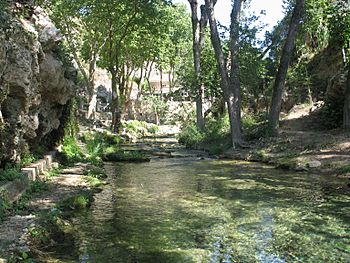
Upper course of the Sénia River in the Ports de Beseit
|
|
| Country | Spain |
| Physical characteristics | |
| Main source | Barranc del Salt, Puertos de Tortosa-Beceite 1,200 m (3,900 ft) |
| River mouth | Sol de Riu, Mediterranean Sea 0 m (0 ft) |
| Length | 49 km (30 mi) |
| Basin features | |
| Basin size | 197.7 km2 (76.3 sq mi) |
The Cenia river is a coastal river in Spain. It flows through the eastern part of the Iberian Peninsula. For much of its journey, it acts as a natural border. It separates the provinces of Castellón and Tarragona. The Cenia river is about 50 km (31 miles) long. It eventually flows into the Mediterranean Sea.
Contents
Where Does the Cenia River Flow?
The Cenia river starts in the Puertos de Tortosa-Beceite mountains. This area is part of the Puebla de Benifasar municipality. The river's water is collected in the Ulldecona dam. This dam is also located in the same municipality. It sits at an elevation of 477 meters (1,565 feet) above sea level.
The Ulldecona Dam
The Ulldecona dam creates a reservoir. This reservoir covers an area of 116 hectares (287 acres). It can hold 11 hm³ (about 9,000 acre-feet) of water. This dam is the only structure that controls the river's flow. Its main purpose is to store water for irrigation, helping farmers water their crops.
The River's Journey
After the dam, the river flows through areas with steep slopes. This makes the water move fast and get lots of oxygen. Many plants grow in this area. They help keep the water clean and provide a good home for fish and other aquatic life. Further downstream, before reaching Cenia, some water is taken from the river. This water is used to irrigate about 2,360 hectares (5,830 acres) of land.
A Natural Border
Just before the town of Cenia, the river becomes a border. It marks the line between Catalonia and the Valencian Community. From this point until it reaches the sea, the Cenia river serves as a natural boundary between these two important regions of Spain.
As the river moves away from this point, it receives very little new water from natural sources. This can cause the water quality to get worse. Near the town of Alcanar, the river enters a flat area called the Plana de Vinaroz. It crosses this plain until it flows into the Mediterranean Sea at a place called Sol de Riu.
What Rivers Join the Cenia?
The Cenia river has some smaller streams that flow into it. These are called tributaries.
- From the left side:
- Barranc dels Terrers: 40°35′54.06″N 0°26′24.75″E / 40.5983500°N 0.4402083°E
Learn More
 In Spanish: Río Cenia para niños
- La Sénia
- List of rivers of Spain
- Taula del Sénia
- Tinença de Benifassà
 | Selma Burke |
 | Pauline Powell Burns |
 | Frederick J. Brown |
 | Robert Blackburn |

