Centerville, North Carolina facts for kids
Quick facts for kids
Centerville, North Carolina
|
|
|---|---|
 |
|

Location of Centerville, North Carolina
|
|
| Country | United States |
| State | North Carolina |
| County | Franklin |
| Established | 1882 |
| Incorporated | May 25, 1965 |
| Dissolved | July 22, 2017 |
| Named for | Central location of area between Louisburg, Warrenton and Littleton. |
| Area | |
| • Total | 1.65 sq mi (4.28 km2) |
| • Land | 1.63 sq mi (4.22 km2) |
| • Water | 0.02 sq mi (0.06 km2) |
| Elevation | 322 ft (98 m) |
| Population
(2020)
|
|
| • Total | 149 |
| • Density | 91.52/sq mi (35.34/km2) |
| Time zone | UTC-5 (Eastern (EST)) |
| • Summer (DST) | UTC-4 (EDT) |
| Area code(s) | 919 and 984 |
| FIPS code | 37-11560 |
| GNIS feature ID | 2791522 |
Centerville is a small community in the northeastern part of Franklin County, North Carolina, United States. It is known as a census-designated place (CDP), which means it's an area identified by the U.S. Census Bureau for statistical purposes. In 2020, about 149 people lived there.
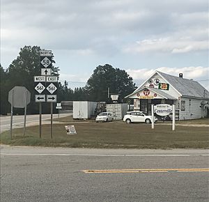
Centerville was once an official town from 1965 until 2017. It doesn't have its own post office or zip code; instead, it uses the one from Louisburg, which is about 12 miles (19 km) away. The heart of Centerville is "the crossroads," where NC-561 and NC-58 meet. You can find two old-fashioned general stores there.
The community has a church called Centerville Baptist Church and a volunteer fire department. Since there isn't a police department, the Franklin County Sheriff's Office helps keep the area safe. Centerville also has many old buildings, like the Serepta Church, which used to be a Methodist church. Two historic places, Perry School and Vine Hill, are listed on the National Register of Historic Places.
Contents
History of Centerville
Centerville began around 1882. It got its name because it was located in the middle of three other towns: Louisburg, Warrenton, and Littleton. It officially became a town in 1965. This happened four years after a nearby town called Wood was no longer a town.
Geography of Centerville
Centerville is a small area of land. According to the United States Census Bureau, it covers about 1.65 square miles (4.28 square kilometers). Almost all of this area is land, with only a tiny bit of water.
Population Changes
The number of people living in Centerville has changed over the years. Here's a quick look at its population:
| Historical population | |||
|---|---|---|---|
| Census | Pop. | %± | |
| 1970 | 123 | — | |
| 1980 | 135 | 9.8% | |
| 1990 | 115 | −14.8% | |
| 2000 | 99 | −13.9% | |
| 2010 | 89 | −10.1% | |
| 2020 | 149 | 67.4% | |
| U.S. Decennial Census | |||
Centerville in 2020
In 2020, the 2020 United States census counted 149 people living in Centerville. These people lived in 103 households, and 85 of these were families.
Centerville in 2010
Back in 2010, when Centerville was still a town, there were 89 people living there. Most of the people (93%) were White. A smaller number (3.5%) were Black, and another 3.5% were from other backgrounds.
Why Centerville Stopped Being a Town
On February 22, 2017, a plan was put forward to stop Centerville from being an official town. The Centerville Town Council had voted to do this because the town wasn't growing. It also didn't have enough money to keep running as a separate municipality.
When the plan passed, the town had 30 days to pay its bills and sell its property. Any money left over was given to the Centerville Fire Department. The bill, called Senate Bill 122, was approved on June 22, 2017. Centerville officially stopped being a town on July 22, 2017.
See also
 In Spanish: Centerville (Carolina del Norte) para niños

