Cerro Batoví facts for kids
Quick facts for kids Cerro Batoví |
|
|---|---|

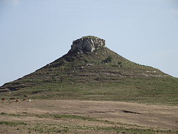
Cerro Batoví, situated near Tacuarembó
|
|
| Highest point | |
| Elevation | 224 m (735 ft) |
| Naming | |
| Language of name | Spanish/Guaraní |
| Pronunciation | Spanish: [ˈθero βatoˈβi] |
| Geography | |
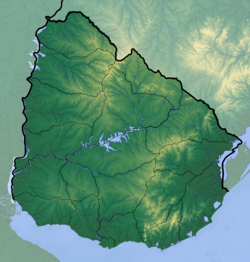
| Location | Tacuarembó, Tacuarembó Department, Uruguay |
| Parent range | Cuchilla de Haedo |
| Geology | |
| Age of rock | Precambrian |
| Mountain type | Hill |
| Climbing | |
| Easiest route | Hike |
Cerro Batoví is a well-known hill in Uruguay. It stands 224 metres (about 735 feet) tall. This makes it a noticeable landmark in the area. It is located about 25 kilometres (15.5 miles) from the city of Tacuarembó.
Where is Cerro Batoví Located?
Cerro Batoví is found in the Tacuarembó Department of Uruguay. It is part of a group of hills called the Cuchilla de Haedo. This area is known for its beautiful natural landscapes.
Why is Cerro Batoví Special?
Cerro Batoví is more than just a hill. It is seen as a very important symbol for the Tacuarembó Department. People in the region are proud of this natural landmark. It represents the spirit and beauty of the area.
See also
 In Spanish: Cerro Batoví para niños
- Cerro Catedral
- Cerro de las Ánimas
- Cerro Pan de Azúcar
- Geography of Uruguay
Black History Month on Kiddle
African-American Labor Activists
 | William Lucy |
 | Charles Hayes |
 | Cleveland Robinson |

All content from Kiddle encyclopedia articles (including the article images and facts) can be freely used under Attribution-ShareAlike license, unless stated otherwise. Cite this article:
Cerro Batoví Facts for Kids. Kiddle Encyclopedia.

