Cerro Catedral (Uruguay) facts for kids
- For the mountain in Argentina, see Cerro Catedral.
Quick facts for kids Cerro Catedral |
|
|---|---|

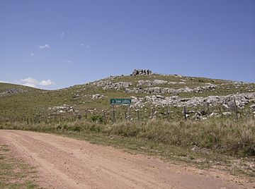
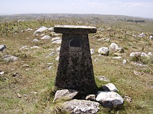
The summit of Cerro Catedral, near a dirt road (Ruta 109).
|
|
| Highest point | |
| Elevation | 513.66 m (1,685.2 ft) |
| Prominence | 373 m (1,224 ft) |
| Listing | Country high point |
| Naming | |
| English translation | Cathedral Hill |
| Language of name | Spanish |
| Pronunciation | Spanish: [ˈsero kateˈðɾal] |
| Geography | |
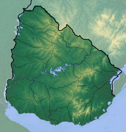
| Location | Aiguá, Maldonado Department, Uruguay |
| Parent range | Sierra Carapé (part of Cuchilla Grande) |
| Geology | |
| Age of rock | Precambrian |
| Mountain type | Hill (granite, gneiss) |
| Climbing | |
| First ascent | Unknown |
| Easiest route | Hike |
Cerro Catedral (which means "Cathedral Hill" in Spanish) is the highest point in Uruguay. It is also sometimes called Cerro Cordillera. This hill reaches a height of 513.66 meters (about 1,685 feet) above sea level.
You can find Cerro Catedral in the northern part of the Maldonado Department. It is located in a hill range called Sierra Carapé, which is part of a larger range known as Cuchilla Grande. The hill gets its name from the interesting shapes of the rocks at its top, which look a bit like a cathedral.
Contents
History of Cerro Catedral
For a long time, people thought that another hill, Cerro de las Ánimas, was the highest point in Uruguay. Cerro de las Ánimas is about 501 meters (1,644 feet) tall.
However, in 1973, a group of scientists from the Servicio Geográfico Militar (which means "Military Geographic Service") measured Cerro Catedral again. They discovered that Cerro Catedral was actually taller than Cerro de las Ánimas. This made Cerro Catedral the official highest point in the country.
Geography of Cerro Catedral
Where is Cerro Catedral?

Cerro Catedral is part of the Sierra Carapé mountain range. This range formed a very long time ago, during the Precambrian era. It stretches across the Maldonado Department from west to east. The Sierra Carapé range also forms a natural border between the Lavalleja Department and the Maldonado Department.
The hill is found in an area called Las Cañas. Near Cerro Catedral, two streams begin: the José Ignacio Stream, which flows south, and the Coronilla Stream, which flows northwest into Aiguá.
What is Cerro Catedral made of?
The rocks that make up Cerro Catedral are mainly granite and gneiss. Granite is a very hard, common type of rock. Gneiss is another type of rock that forms when other rocks are changed by heat and pressure.
Plants on Cerro Catedral
At the very top of Cerro Catedral, there isn't much plant life because of the rocky conditions. You might see a few small shrubs like Myrtus ugni growing between the rocks.
Below 400 meters (about 1,312 feet), you'll find more plants. Tough grasses grow here, along with plants that can survive in dry conditions. You can also spot shrubs like Baccharis articulata and marcela (Achyrocline satureioides).
Weather at Cerro Catedral
The climate around Cerro Catedral is an Oceanic climate. This means it has mild to warm summers and cool winters. It often gets frosts in winter.
Strong winds are very common in this area. Rain falls fairly evenly throughout the year. It is very rare for it to snow at Cerro Catedral.
| Climate data for Cerro Catedral (514 metres - modelled data) | |||||||||||||
|---|---|---|---|---|---|---|---|---|---|---|---|---|---|
| Month | Jan | Feb | Mar | Apr | May | Jun | Jul | Aug | Sep | Oct | Nov | Dec | Year |
| Mean daily maximum °C (°F) | 26 (79) |
25 (77) |
23 (73) |
19 (66) |
16 (61) |
14 (57) |
13 (55) |
15 (59) |
16 (61) |
19 (66) |
21 (70) |
24 (75) |
19 (67) |
| Mean daily minimum °C (°F) | 14 (57) |
14 (57) |
13 (55) |
10 (50) |
7 (45) |
5 (41) |
4 (39) |
5 (41) |
6 (43) |
8 (46) |
10 (50) |
12 (54) |
9 (48) |
| Average precipitation mm (inches) | 69 (2.7) |
101 (4.0) |
98 (3.9) |
93 (3.7) |
83 (3.3) |
74 (2.9) |
82 (3.2) |
70 (2.8) |
74 (2.9) |
102 (4.0) |
103 (4.1) |
77 (3.0) |
1,026 (40.5) |
| Source: MeteoBlue | |||||||||||||
See also
 In Spanish: Cerro Catedral (Uruguay) para niños
- Cerro Pan de Azúcar
- Geography of Uruguay
 | Emma Amos |
 | Edward Mitchell Bannister |
 | Larry D. Alexander |
 | Ernie Barnes |


