Cerro Quiac facts for kids

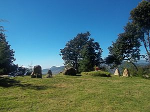
Cerro Quiac occupies the summit of a hill overlooking Cantel
|
|
| Alternative names | K'iaq K'iaqb'al |
|---|---|
| Geographical range | Guatemalan Highlands |
| Period | Maya |
| Type site | Archaeological |
Cerro Quiac (pronounced see-ROH kee-AHK) is a small ancient Maya site located high in the Guatemalan Highlands. It sits on a hill about 2,635 meters (8,645 feet) above sea level. This special place overlooks the Plains of Urbina.
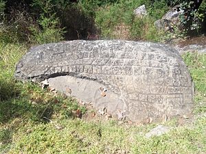
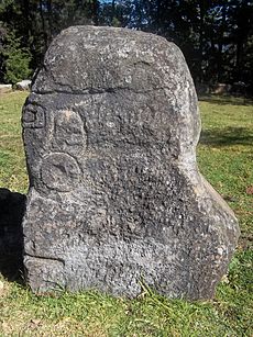
When experts first studied the site in 1970, they found five stone sculptures. By 1977, only four were left. These sculptures showed figures and cool geometric designs. Even today, local Maya people use Cerro Quiac for important ceremonies. The site is in the town of Cantel, in a small area called Chirijquiac.
Cerro Quiac has two small groups of ancient buildings. Old documents from the early colonial period say it was a fort built by the Mam Maya. Later, the Kʼicheʼ Maya took over the area. Experts believe Cerro Quiac was used between about 900 and 1200 AD. Local Kʼicheʼ stories say the site was a training ground for Kʼicheʼ warriors. Some even say the famous Kʼicheʼ hero Tecun Uman died on this very hill.
Contents
What's in a Name?
The name of the hill, Quiac, might come from the Kʼicheʼ word kʼiaq. This word means "flea." Another idea is that it comes from a small black flower that grows on the hill. Cerro is a Spanish word meaning "hill." The name Kʼiaqbʼal for the ancient site means "place of throwing" or "place of shooting."
Where is Cerro Quiac?
The site is south of the Plains of Urbina. It's about 2 kilometers (1.2 miles) east of the Samala River. The hill is very noticeable and can be seen for about 4 kilometers (2.5 miles) in every direction. The top of the hill is covered with pine trees.
The hilltop is a long ridge, about 100 meters (330 feet) long. It varies in width from 20 to 100 meters (65 to 330 feet). The sides of the hill are steep. The easiest way to get to the top is from the northeast side. The western part of the ridge is the highest. It rises about 160 meters (525 feet) above the valley floor.
Exploring the Ancient Site
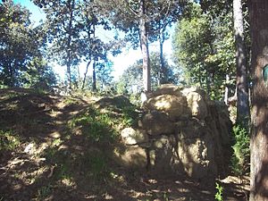
The ancient buildings were built on the western part of the ridge. They run from northwest to southeast. Large rocks were used to create terraces. These terraces are about 2 meters (6.5 feet) and 3 meters (10 feet) high. There are two main groups of buildings, but they are not very well preserved.
East Group
The east group has three earth mounds arranged in a line. A fourth mound is located to the south. There are steep drops on the east and west sides of this group. Many pieces of ancient pottery were found here. They were uncovered by farming activities.
West Group
The west group is about 170 meters (560 feet) from the east group. It sits about 70 meters (230 feet) higher. A small temple was built on a wide platform, about 1 meter (3 feet) high. The walls of this platform were made from rough, uncut stones. In the 1970s, five ancient stone monuments, called stelae, stood on this platform.
The five stelae found in 1970 were arranged in a half-circle. It's possible they were brought to Cerro Quiac from other nearby sites. The sculptures were very old and worn down. Several ancient tombs were also found on the hill. Different artifacts were recovered from these tombs.
History of Cerro Quiac
Pieces of pottery found at the site show it was used during the Early Postclassic period. This was roughly from 950 to 1200 AD. An old Kʼicheʼ document, called Título C'oyoi, says Cerro Quiac was a fort. It was built by the Mam Maya from a place called Zaculeu. There is no sign that people lived here after the Kʼicheʼ Maya took over from the Mam. The pottery and stelae found here are likely from the Mam people, dating to the 13th or 14th century AD.
More Recent History
In September 1884, during a time of political tension, some government cannons were placed on Cerro Quiac. This was done to show power and encourage the people of Cantel to follow government rules. Local stories sometimes mix this event with resistance to building a textile factory.
In 1968, during a period of conflict in Guatemala, officials from Quetzaltenango wanted to buy the hill. They planned to build a military base there. But the people of Cantel refused to sell the land. As a community, they argued that Cerro Quiac was an important archaeological site. Different churches in Cantel worked together to make the hill a special place for prayer. Today, it is the most important Maya ceremonial site in Cantel. On June 28, 2004, it was officially declared a national cultural and natural heritage site.
Local Stories and Legends
Local stories say the hill was formed by an eruption of the Cerro Quemado volcano. The legend says a great leap from Cerro Quemado to this hill gave it the name K'iaq, like the jump of a flea. Traditionally, the ancient site was called Kʼiaqbal. It is said to have been a training ground for Kʼicheʼ warriors.
The hill is also linked in local stories to the Kʼicheʼ hero Tecun Uman. He fought against Pedro de Alvarado during the Spanish conquest of Guatemala. One story says that Tecun Uman was killed on this very hill.
See also
 In Spanish: Cerro Quiac para niños
 | Jackie Robinson |
 | Jack Johnson |
 | Althea Gibson |
 | Arthur Ashe |
 | Muhammad Ali |


