Chajul facts for kids
Quick facts for kids
Chajul
San Gaspar Chajul
|
|
|---|---|
|
Municipality
|
|

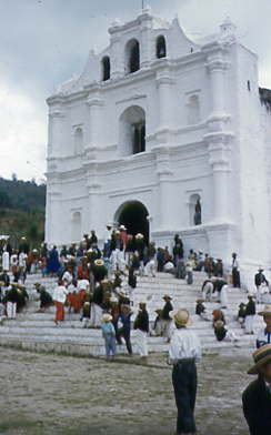
Church in Chajul in the 1950s
|
|
| Country | |
| Department | |
| Municipality | Chajul |
| Government | |
| • Type | Municipal |
| Area | |
| • Municipality | 276 sq mi (716 km2) |
| Population
(Census 2018)
|
|
| • Municipality | 46,658 |
| • Density | 168.78/sq mi (65.16/km2) |
| • Urban | 24,247 |
| • Ethnicities | Ixil K'iche' people Ladino |
| • Religions | Roman Catholicism Evangelicalism Maya |
| Climate | Cfb |
Chajul (pronounced cha-HOOL) is a town and municipality in Guatemala. It is located in the El Quiché area. Chajul is part of a special region called the Ixil Community. This community also includes the towns of San Juan Cotzal and Santa María Nebaj. The Ixil region is surrounded by beautiful mountains. Because of this, the people have kept their rich Maya traditions and language.
Chajul, Nebaj, and Cotzal form the Ixil Region in the Western Highlands of Guatemala. This area was at the center of a long civil war that lasted 36 years. After the war, Chajul faced many challenges. These included emotional difficulties, land problems, and families being separated. Also, many people do not have jobs. Large families often live in small adobe houses. Women have few opportunities, and family problems are common.
The community mostly relies on farming corn to live. Adults work hard every day to feed their families. The average income is very low, about $1–3 per day. A study in 2002 showed that very few children finish high school. Most have to leave school early to help their families. This means about 75% of adults cannot read or write. Chajul also has common health problems. These include breathing issues, stomach sickness, and poor nutrition. About 80% of the people in Chajul live in poverty.
Contents
History of Chajul
The Northern Transversal Strip
Lua error in Module:Location_map at line 420: attempt to index field 'wikibase' (a nil value). The Northern Transversal Strip was a special area created by the government in 1970. It was meant for farming and development. A law was passed to make this area important for the country. The law included many towns, such as Chajul, in this development plan.
The Guerrilla Army of the Poor
In 1972, a new group of fighters entered Guatemala from Mexico. Many farmers welcomed them. This group aimed to bring social justice to the people. In 1973, they set up a hidden camp in the mountains near Chajul.
By 1974, this group held its first meeting. They decided on their plans and called themselves the Guerrilla Army of the Poor (EGP). By 1975, the group had grown and spread around the mountains of Nebaj and Chajul. The EGP wanted to show that they were fighting against unfairness. They wanted to help the local people, especially the Maya farmers, to join their cause. They believed the government was not helping the people enough.
The EGP decided to take actions against people they believed were causing problems for the communities. They listened to complaints from local people to decide who to act against. For example, they targeted a large landowner who was said to have land conflicts and treat his workers badly. These actions were meant to make the local people feel that the EGP was on their side.
On June 7, 1975, one of these landowners was killed at his farm. Many people were there to get their pay. Members of the EGP were hidden among the farmers. After the event, the EGP members spoke in the Ixil language. They told the farmers they were from the Guerrilla Army of the Poor. They explained that they had acted against the landowner because of his alleged crimes against the community. Then, the attackers left towards Chajul.
The son of the landowner reported the event to the Minister of Defense. However, the general did not believe him. He said there were no such groups in the area. This shows how difficult the situation was during the civil war.
Climate
Chajul has an oceanic climate. This means it has cool summers and mild winters. It also has rain throughout the year.
| Climate data for Chajul | |||||||||||||
|---|---|---|---|---|---|---|---|---|---|---|---|---|---|
| Month | Jan | Feb | Mar | Apr | May | Jun | Jul | Aug | Sep | Oct | Nov | Dec | Year |
| Mean daily maximum °C (°F) | 20.6 (69.1) |
21.6 (70.9) |
23.4 (74.1) |
24.0 (75.2) |
23.4 (74.1) |
22.5 (72.5) |
21.8 (71.2) |
22.2 (72.0) |
22.1 (71.8) |
21.1 (70.0) |
21.3 (70.3) |
21.0 (69.8) |
22.1 (71.7) |
| Daily mean °C (°F) | 14.6 (58.3) |
15.1 (59.2) |
16.6 (61.9) |
17.4 (63.3) |
17.5 (63.5) |
17.5 (63.5) |
16.7 (62.1) |
16.7 (62.1) |
16.8 (62.2) |
16.1 (61.0) |
15.7 (60.3) |
15.2 (59.4) |
16.3 (61.4) |
| Mean daily minimum °C (°F) | 8.7 (47.7) |
8.7 (47.7) |
9.9 (49.8) |
10.8 (51.4) |
11.6 (52.9) |
12.5 (54.5) |
11.7 (53.1) |
11.2 (52.2) |
11.6 (52.9) |
11.2 (52.2) |
10.1 (50.2) |
9.5 (49.1) |
10.6 (51.1) |
| Average precipitation mm (inches) | 65 (2.6) |
42 (1.7) |
50 (2.0) |
66 (2.6) |
128 (5.0) |
306 (12.0) |
265 (10.4) |
230 (9.1) |
251 (9.9) |
224 (8.8) |
127 (5.0) |
64 (2.5) |
1,818 (71.6) |
| Source: Climate-Data.org | |||||||||||||
Geographic Location
Chajul is surrounded by other towns in the El Quiché Department:
 |
Ixcán |  |
||
| Nebaj | Uspantán | |||
| San Juan Cotzal |
See also
 In Spanish: Chajul para niños
 | Tommie Smith |
 | Simone Manuel |
 | Shani Davis |
 | Simone Biles |
 | Alice Coachman |


