
Chantenay-Villedieu facts for kids
Quick facts for kids
Chantenay-Villedieu
|
|
|---|---|
.JPG) |
|

Chantenay-Villedieu
Location in France

Chantenay-Villedieu
Location in Pays de la Loire
|
|
| Country | France |
| Region | Pays de la Loire |
| Department | Sarthe |
| Arrondissement | La Flèche |
| Canton | Loué |
| Intercommunality | Loué-Brûlon-Noyen |
| Area
1
|
27.74 km2 (10.71 sq mi) |
| Population
(Jan. 2019)
|
841 |
| • Density | 30.317/km2 (78.52/sq mi) |
| Demonym(s) | Chantenaysien, Chantenaysienne |
| Time zone | UTC+01:00 (CET) |
| • Summer (DST) | UTC+02:00 (CEST) |
| INSEE/Postal code |
72059 /72430
|
| Elevation | 35–101 m (115–331 ft) |
| 1 French Land Register data, which excludes lakes, ponds, glaciers > 1 km2 (0.386 sq mi or 247 acres) and river estuaries. | |
Chantenay-Villedieu is a small town, also known as a commune, located in the western part of France. It is found in the Sarthe department, which is part of the region called Pays de la Loire.
Contents
What is a Commune?
In France, a commune is the smallest type of administrative area. Think of it like a local town or village. Each commune has its own local government. This government helps manage things like local services and public spaces.
Where is Chantenay-Villedieu?
Chantenay-Villedieu is situated in the Sarthe department. This area is known for its green landscapes. The commune is part of the Pays de la Loire region. This region is famous for its beautiful castles and the Loire River.
How Many People Live There?
As of January 2019, about 841 people lived in Chantenay-Villedieu. This makes it a fairly small and quiet community. People from Chantenay-Villedieu are called Chantenaysien (for males) or Chantenaysienne (for females).
Local Government
Like all communes in France, Chantenay-Villedieu has a mayor. The mayor is the head of the local government. They are responsible for running the commune. From 2008 to 2014, the mayor was Christian Chanal. The commune also works with other nearby towns. This is called intercommunality. Chantenay-Villedieu is part of the Loué-Brûlon-Noyen group.
Geography and Landscape
The commune covers an area of about 27.74 square kilometers. The land here varies in height. The lowest point is 35 meters above sea level. The highest point reaches 101 meters. This means there are some gentle hills and valleys in the area.
Images for kids
-
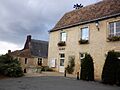
A view of Chantenay-Villedieu.
See also
 In Spanish: Chantenay-Villedieu para niños
