Charlemont Village Historic District facts for kids
Quick facts for kids |
|
|
Charlemont Village Historic District
|
|

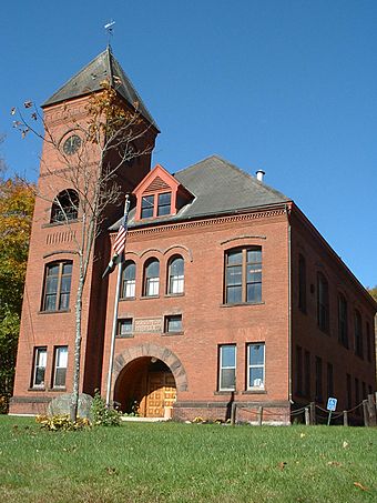
Charlemont Town Hall
|
|
| Location | Main St., Charlemont, Massachusetts |
|---|---|
| Area | 50 acres (20 ha) |
| Architectural style | Greek Revival, Late Victorian, Federal |
| NRHP reference No. | 87001880 |
| Added to NRHP | February 10, 1988 |
The Charlemont Village Historic District is a special area in Charlemont, Massachusetts. It's located along Massachusetts Route 2, between South Street and Harmony Lane. This district shows how the village grew from a small farming area to a busy center. You can see buildings from the 1700s and 1800s here. These include old farmhouses and buildings with different styles, like Greek Revival and Victorian. This historic district was added to the National Register of Historic Places in 1988.
Contents
Exploring Charlemont's Past
How Charlemont Began
People first explored the Charlemont area in 1736. Families started settling here in the early 1740s. They even built a grist mill, which grinds grain into flour, on Mill Brook. The village was left empty during King George's War in the late 1740s. But settlers soon returned after the war ended.
Growing into a Town
The town's population grew a lot in the 1760s. Charlemont officially became a town in 1765. The village was an important stop for travelers. An early tavern stood where the Charlemont Inn is today. It's even said that Benedict Arnold stayed there during the early days of the American Revolutionary War.
Farming and Industry
The town's economy mainly relied on farming. The rich soil near the Deerfield River was perfect for crops. In the mid-1800s, Charlemont grew even more. This happened when workers came to build the Hoosac Tunnel. The town continued to grow until the end of the 1800s.
Changes in the 1900s
In the early 1900s, things changed for Charlemont. Cars became popular, and small local businesses slowed down. This caused the village's economy to become less active.
What You Can See in the District
A Walk Through History
The historic district stretches for about 1 mile (1.6 km). It follows Massachusetts Route 2, which is the main road through town. The district starts near Harmony Lane in the west. It ends at South Street in the east.
Important Buildings to Spot
Many interesting buildings are part of this district. Besides the old inn, you can see the Baptist church, built in 1803. It was actually moved to this spot later on! There's also a two-story schoolhouse from 1831.
You'll find churches built in the Greek Revival style. These were for the Congregationalist and Methodist groups. The town hall is also a key building. It's a grand brick building from 1892, built in a style called Romanesque.


