
Charley Run (Allegheny River tributary) facts for kids
Quick facts for kids Charley Run |
|
|---|---|


|
|
| Other name(s) | Tributary to Allegheny River |
| Country | United States |
| State | Pennsylvania |
| County | Venango |
| City | Oil City |
| Physical characteristics | |
| Main source | Read Run divide about 2 miles north of Oil City, Pennsylvania 1,440 ft (440 m) 41°27′12″N 079°44′26″W / 41.45333°N 79.74056°W |
| River mouth | Allegheny River Oil City, Pennsylvania 974 ft (297 m) 41°25′35″N 079°43′32″W / 41.42639°N 79.72556°W |
| Length | 1.78 mi (2.86 km) |
| Basin features | |
| Progression | south-southeast |
| River system | Allegheny River |
| Basin size | 1.35 square miles (3.5 km2) |
| Tributaries |
|
| Bridges | US 62 |
Charley Run is a small stream, about 1.78 miles (2.86 km) long, located in Venango County, Pennsylvania. It's known as a "first-order tributary," which means it's one of the smallest streams that flows into a larger river. Charley Run eventually joins the mighty Allegheny River.
Where Does Charley Run Begin and End?
Charley Run starts its journey about 2 miles (3.2 km) north of Oil City, Pennsylvania. It flows generally towards the south-southeast. Its path ends when it flows into the Allegheny River, right in Oil City, Pennsylvania.
What is Charley Run's Watershed Like?
A watershed is the area of land where all the water drains into a particular river or stream. Charley Run's watershed covers about 1.35 square miles (3.5 sq km). This area gets a good amount of rain each year, around 44.4 inches (113 cm). Most of the land in this watershed, about 90%, is covered by forests. This helps keep the water clean and the environment healthy.
Images for kids
-
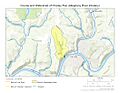
This map shows the path of Charley Run and its watershed in Venango County, Pennsylvania.
.jpg)
