Chatham Heights, Virginia facts for kids
Quick facts for kids
Chatham Heights, Virginia
|
|
|---|---|

|
|
| Country | United States |
| State | Virginia |
| County | Stafford |
| Elevation | 89 ft (27 m) |
| Time zone | UTC−5 (Eastern (EST)) |
| • Summer (DST) | UTC−4 (EDT) |
| Area code(s) | 540 |
| GNIS feature ID | 1494872 |
Chatham Heights is a small place in Stafford County, Virginia. It is called an unincorporated community. This means it is a group of homes and businesses that are not part of a city or town. Instead, it is managed by the county government.
Where is Chatham Heights?
Chatham Heights is located in the state of Virginia. It sits about 89 feet (27 meters) above the Rappahannock River. The community is found east of the city of Fredericksburg. It is also southeast of a place called Falmouth.
Getting Around in Chatham Heights
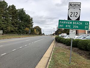
Chatham Heights has several important roads. Virginia State Route 212 runs north and south right through the middle of the community. This road is also known as Chatham Heights Road.
Another road, Virginia State Route 218, helps connect Chatham Heights to U.S. Route 1 in the north. In the south, Virginia Route 3 Business also serves the area.
You can also get around using public transportation. The Fredericksburg Regional Transit offers a bus service called FRED. This bus service operates within Chatham Heights.
For longer trips, there are train services nearby. The RF&P Subdivision train tracks pass by the east side of the community. Across the Rappahannock River, you can find the Fredericksburg station. From this station, you can catch Amtrak trains or use the Virginia Railway Express for travel.


