Cherry Fork, Ohio facts for kids
Quick facts for kids
Cherry Fork, Ohio
|
|
|---|---|

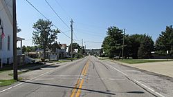
Southbound on State Route 136
|
|

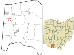
Location in Adams County and the state of Ohio.
|
|
| Country | United States |
| State | Ohio |
| County | Adams |
| Township | Wayne |
| Area | |
| • Total | 0.30 sq mi (0.78 km2) |
| • Land | 0.30 sq mi (0.78 km2) |
| • Water | 0.00 sq mi (0.00 km2) |
| Elevation | 892 ft (272 m) |
| Population
(2020)
|
|
| • Total | 170 |
| • Density | 562.91/sq mi (217.36/km2) |
| Time zone | UTC-5 (Eastern (EST)) |
| • Summer (DST) | UTC-4 (EDT) |
| ZIP code |
45618
|
| Area code(s) | 937, 326 |
| FIPS code | 39-13834 |
| GNIS feature ID | 2785006 |
Cherry Fork is a small community located in Adams County, Ohio, United States. It is known as an "unincorporated community." This means it doesn't have its own local government like a city or town. Instead, it's part of a larger area called Wayne Township.
Cherry Fork used to be a small village. However, in 2014, the people living there voted for it to become an unincorporated community. According to the 2020 census, about 170 people live in Cherry Fork.
Contents
History of Cherry Fork
Cherry Fork has an interesting past. It was first established in 1848. When it was first created, it had a different name: North Liberty.
The community later changed its name to Cherry Fork. This new name came from a nearby stream also called Cherry Fork.
Geography of Cherry Fork
Cherry Fork is a small area of land. According to official measurements, the community covers about 0.12 square miles (0.31 km2) of land. There is no water area within its boundaries.
Population and People
Understanding the population of a place helps us learn about the people who live there. This information is called "demographics."
| Historical population | |||
|---|---|---|---|
| Census | Pop. | %± | |
| 1930 | 195 | — | |
| 1940 | 219 | 12.3% | |
| 1950 | 197 | −10.0% | |
| 1960 | 185 | −6.1% | |
| 1970 | 176 | −4.9% | |
| 1980 | 210 | 19.3% | |
| 1990 | 178 | −15.2% | |
| 2000 | 127 | −28.7% | |
| 2010 | 155 | 22.0% | |
| 2020 | 170 | 9.7% | |
| U.S. Decennial Census | |||
Cherry Fork's Population in 2010
Let's look at some details from the census taken in 2010:
- Total Population: There were 155 people living in Cherry Fork.
- Households: There were 64 households. A household is a group of people living together in one home.
- Families: Out of these households, 38 were families.
- Population Density: The population density was about 1,291.7 inhabitants per square mile (498.7/km2). This means there were about 1,292 people for every square mile.
- Housing: There were 75 housing units in total.
- Racial Background: Most residents (96.8%) were White. A small number were African American (0.6%), Native American (0.6%), or from two or more races (1.9%). About 0.6% of the population identified as Hispanic or Latino.
- Age Groups:
- About 29% of the people were under 18 years old.
- About 10.3% of the people were 65 years old or older.
- Gender: Slightly more than half of the residents (54.2%) were male, and 45.8% were female.
See also
 In Spanish: Cherry Fork (Ohio) para niños
 | John T. Biggers |
 | Thomas Blackshear |
 | Mark Bradford |
 | Beverly Buchanan |

