
Cherrytree Run (Oil Creek tributary) facts for kids
Quick facts for kids Cherrytree Run |
|
|---|---|


Location of the mouth of Cherrytree Run
|
|
| Other name(s) | Tributary to Oil Creek |
| Country | United States |
| State | Pennsylvania |
| Counties | Venango |
| Physical characteristics | |
| Main source | divide between Cherrytree Run and Prather Creek (French Creek Drainage) about 0.5 miles west of Toonerville, Pennsylvania 1,540 ft (470 m) 41°34′41″N 079°42′29″W / 41.57806°N 79.70806°W |
| River mouth | Oil Creek Rynd Farm, Pennsylvania 1,048 ft (319 m) 41°28′52″N 079°41′41″W / 41.48111°N 79.69472°W |
| Length | 8.0 mi (12.9 km) |
| Basin features | |
| Progression | generally south |
| River system | Allegheny River |
| Basin size | 16.9 square miles (44 km2) |
| Population | 724 (2010) |
| Tributaries |
|
Cherrytree Run is a small stream, about 8.0 mi (12.9 km) long, located in Venango County, Pennsylvania. It flows into Oil Creek. A "run" is a small stream, and a "tributary" is a stream or river that flows into a larger stream or river. This stream shares its name with the area it flows through, Cherrytree Township.
Contents
What's in a Name?
Sometimes, places have more than one name over time. Cherrytree Run has also been known as:
- Cherry Tree Run
This information comes from the Geographic Names Information System (GNIS). The GNIS is like a big database of names and locations for physical features in the United States.
Where Does Cherrytree Run Start and End?
Cherrytree Run begins near a place called Toonerville, Pennsylvania. It starts on a high area that separates it from Prather Creek. From there, the stream flows generally south. It eventually joins Oil Creek at a spot known as Rynd Farm.
Understanding the Watershed
What is a Watershed?
A watershed is an area of land where all the water drains into a single stream, river, or lake. Think of it like a giant bowl where all the rain and snowmelt collect and flow towards one exit point.
Cherrytree Run's Watershed Details
The watershed for Cherrytree Run covers about 16.9 square miles (44 km2) of land. This area gets about 44.9 inches of rain and snow each year. Most of the land in the watershed, about 75%, is covered by forests. The average water temperature in the run is about 7.79 degrees Celsius.
Images for kids
-
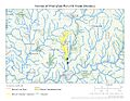
This map shows the path of Cherrytree Run.
-
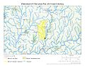
This map shows the entire area that drains into Cherrytree Run.
.jpg)
.jpg)
