Chesapeake, Missouri facts for kids
Quick facts for kids
Chesapeake, Missouri
|
|
|---|---|

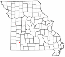
Location of Chesapeake in Missouri
|
|
| Country | United States |
| State | Missouri |
| County | Lawrence |
| Area | |
| • Total | 0.45 sq mi (1.16 km2) |
| • Land | 0.45 sq mi (1.15 km2) |
| • Water | 0.00 sq mi (0.00 km2) |
| Population
(2020)
|
|
| • Total | 48 |
| • Density | 107.87/sq mi (41.62/km2) |
| FIPS code | 29-13582 |
| GNIS feature ID | 2587059 |
Chesapeake is a small place in Lawrence County, Missouri, United States. It's called an unincorporated community, which means it doesn't have its own local government like a city or town. It's also a census-designated place, which is an area the government counts for population.
Chesapeake is located on Route 174. It's about five miles east of a town called Mount Vernon. In 2020, only 48 people lived there.
What's in Chesapeake Today?
Chesapeake is home to a special place called a fish hatchery. This hatchery is run by the Missouri Department of Conservation. A fish hatchery is like a farm for fish. They raise young fish there. These fish are then released into rivers and lakes. This helps keep fish populations healthy for fishing and the environment.
A Look at Chesapeake's History
Chesapeake has been around for a long time. A post office was opened here in 1850. It helped people send and receive mail. The post office stayed open for many years. It finally closed its doors in 1914.
The name "Chesapeake" has an interesting origin. It remembers an important event in history. This event was the Capture of USS Chesapeake. This was a famous naval battle. It happened during the War of 1812. The American ship USS Chesapeake was captured by the British. The community was named to honor this historical moment.
See also
 In Spanish: Chesapeake (Misuri) para niños
 | Ernest Everett Just |
 | Mary Jackson |
 | Emmett Chappelle |
 | Marie Maynard Daly |

